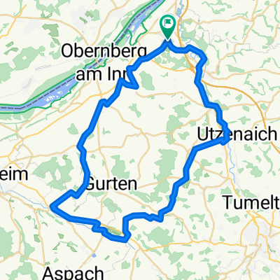
Peti&Zoli
A cycling route starting in Sankt Marienkirchen bei Schärding, Upper Austria, Austria.
Overview
About this route
- 1 h 45 min
- Duration
- 22.3 km
- Distance
- 564 m
- Ascent
- 566 m
- Descent
- 12.8 km/h
- Avg. speed
- ---
- Max. altitude
Route photos
Route quality
Waytypes & surfaces along the route
Waytypes
Quiet road
12.3 km
(55 %)
Track
1.3 km
(6 %)
Surfaces
Paved
5.1 km
(23 %)
Unpaved
0.4 km
(2 %)
Asphalt
5.1 km
(23 %)
Gravel
0.2 km
(1 %)
Continue with Bikemap
Use, edit, or download this cycling route
You would like to ride Peti&Zoli or customize it for your own trip? Here is what you can do with this Bikemap route:
Free features
- Save this route as favorite or in collections
- Copy & plan your own version of this route
- Sync your route with Garmin or Wahoo
Premium features
Free trial for 3 days, or one-time payment. More about Bikemap Premium.
- Navigate this route on iOS & Android
- Export a GPX / KML file of this route
- Create your custom printout (try it for free)
- Download this route for offline navigation
Discover more Premium features.
Get Bikemap PremiumFrom our community
Other popular routes starting in Sankt Marienkirchen bei Schärding
- Sigh._Schwarzenberg_Langenpeuerb._Steegen_Adenbruck_Zell_Andorf_Sigh.
- Distance
- 44.8 km
- Ascent
- 357 m
- Descent
- 360 m
- Location
- Sankt Marienkirchen bei Schärding, Upper Austria, Austria
- ¿øtˇ? nach ¿øtˇ?
- Distance
- 30.2 km
- Ascent
- 509 m
- Descent
- 505 m
- Location
- Sankt Marienkirchen bei Schärding, Upper Austria, Austria
- Höhentour durchs Innviertel
- Distance
- 43.1 km
- Ascent
- 317 m
- Descent
- 318 m
- Location
- Sankt Marienkirchen bei Schärding, Upper Austria, Austria
- 4774 Bründlkapelle
- Distance
- 17.6 km
- Ascent
- 191 m
- Descent
- 194 m
- Location
- Sankt Marienkirchen bei Schärding, Upper Austria, Austria
- Sigharting-Zell/Pr.-Riedau-Kimpling-Zell/Pr-Linden-Sigharting
- Distance
- 51.2 km
- Ascent
- 244 m
- Descent
- 245 m
- Location
- Sankt Marienkirchen bei Schärding, Upper Austria, Austria
- Ort-Obernberg-Schärding-Teufenbach-Ort
- Distance
- 56.2 km
- Ascent
- 267 m
- Descent
- 264 m
- Location
- Sankt Marienkirchen bei Schärding, Upper Austria, Austria
- Sigh._Andorf_Taiskirchen_Wimmer Stubn_Andorf_Sigh
- Distance
- 54.6 km
- Ascent
- 253 m
- Descent
- 254 m
- Location
- Sankt Marienkirchen bei Schärding, Upper Austria, Austria
- Würding Aigen am Inn
- Distance
- 41.3 km
- Ascent
- 68 m
- Descent
- 68 m
- Location
- Sankt Marienkirchen bei Schärding, Upper Austria, Austria
Open it in the app