

AT - Day 8 - Weissensee
A cycling route starting in Heinfels, Tyrol, Austria.
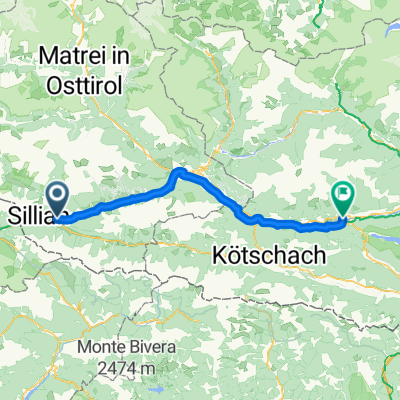
Overview
About this route
Camping Lienzer Dolomiten (Tassenbach) - Seecamping Müller (Weissesnsee)
- -:--
- Duration
- 74 km
- Distance
- 445 m
- Ascent
- 583 m
- Descent
- ---
- Avg. speed
- ---
- Max. altitude

Route quality
Waytypes & surfaces along the route
Waytypes
Cycleway
25.2 km
(34 %)
Track
23.7 km
(32 %)
Surfaces
Paved
60.7 km
(82 %)
Unpaved
8.1 km
(11 %)
Asphalt
52.5 km
(71 %)
Paved (undefined)
8.1 km
(11 %)
Continue with Bikemap
Use, edit, or download this cycling route
You would like to ride AT - Day 8 - Weissensee or customize it for your own trip? Here is what you can do with this Bikemap route:
Free features
- Save this route as favorite or in collections
- Copy & plan your own version of this route
- Sync your route with Garmin or Wahoo
Premium features
Free trial for 3 days, or one-time payment. More about Bikemap Premium.
- Navigate this route on iOS & Android
- Export a GPX / KML file of this route
- Create your custom printout (try it for free)
- Download this route for offline navigation
Discover more Premium features.
Get Bikemap PremiumFrom our community
Other popular routes starting in Heinfels
 Überschreitung Defreggental ins Winkltal
- Distance
- 95.4 km
- Ascent
- 2,484 m
- Descent
- 2,484 m
- Location
- Heinfels, Tyrol, Austria
 AT - Day 8 - Weissensee
- Distance
- 74 km
- Ascent
- 445 m
- Descent
- 583 m
- Location
- Heinfels, Tyrol, Austria
 AT - Day 7 - Drauradweg SP (IT)
- Distance
- 65.5 km
- Ascent
- 349 m
- Descent
- 353 m
- Location
- Heinfels, Tyrol, Austria
 Drauraweg
- Distance
- 258.5 km
- Ascent
- 280 m
- Descent
- 981 m
- Location
- Heinfels, Tyrol, Austria
 2023_1_lesachtal_
- Distance
- 51.4 km
- Ascent
- 1,357 m
- Descent
- 1,728 m
- Location
- Heinfels, Tyrol, Austria
 4 etapa tasenbach(AUS)-canizei(ITA)
- Distance
- 109.2 km
- Ascent
- 2,079 m
- Descent
- 1,709 m
- Location
- Heinfels, Tyrol, Austria
 O07LienzerDolomitenGreifenburgBadesee
- Distance
- 69.3 km
- Ascent
- 747 m
- Descent
- 1,231 m
- Location
- Heinfels, Tyrol, Austria
![[i] OT - Auf zum Zonk(olonc)..!](https://media.bikemap.net/routes/7154034/staticmaps/in_3e05b69e-3824-41e9-b169-8e0a464a1311_400x400_bikemap-2021-3D-static.png) [i] OT - Auf zum Zonk(olonc)..!
[i] OT - Auf zum Zonk(olonc)..!- Distance
- 185.6 km
- Ascent
- 2,787 m
- Descent
- 2,785 m
- Location
- Heinfels, Tyrol, Austria
Open it in the app