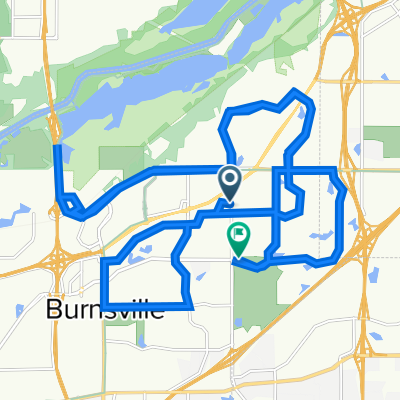
B2B00477 55337>55144 via High Line Trl, Deerwood Dr, Wescott Rd, Delaware Rd, Charlton St
A cycling route starting in Burnsville, Minnesota, United States of America.
Overview
About this route
Return trip would have to use 6th St E (from E 5th St) to get onto Cedar which would lead you to Kellogg Blvd where you can turn onto Wabasha to get onto the bridge.Â
- -:--
- Duration
- 42.2 km
- Distance
- 276 m
- Ascent
- 256 m
- Descent
- ---
- Avg. speed
- ---
- Avg. speed
Route quality
Waytypes & surfaces along the route
Waytypes
Undefined
42.2 km
(100 %)
Surfaces
Undefined
42.2 km
(100 %)
Route highlights
Points of interest along the route
Point of interest after 5.9 km
High Line Trail
Continue with Bikemap
Use, edit, or download this cycling route
You would like to ride B2B00477 55337>55144 via High Line Trl, Deerwood Dr, Wescott Rd, Delaware Rd, Charlton St or customize it for your own trip? Here is what you can do with this Bikemap route:
Free features
- Save this route as favorite or in collections
- Copy & plan your own version of this route
- Sync your route with Garmin or Wahoo
Premium features
Free trial for 3 days, or one-time payment. More about Bikemap Premium.
- Navigate this route on iOS & Android
- Export a GPX / KML file of this route
- Create your custom printout (try it for free)
- Download this route for offline navigation
Discover more Premium features.
Get Bikemap PremiumFrom our community
Other popular routes starting in Burnsville
- B2B00477 55337>55144 via High Line Trl, Deerwood Dr, Wescott Rd, Delaware Rd, Charlton St
- Distance
- 42.2 km
- Ascent
- 276 m
- Descent
- 256 m
- Location
- Burnsville, Minnesota, United States of America
- B2B00496 55337>55102 via Hwy 13, Bg Rvr Trl, Watter St
- Distance
- 23.9 km
- Ascent
- 180 m
- Descent
- 239 m
- Location
- Burnsville, Minnesota, United States of America
- Cleary Lake Campground - Prior Lake, Mn
- Distance
- 15.7 km
- Ascent
- 78 m
- Descent
- 76 m
- Location
- Burnsville, Minnesota, United States of America
- B2B00769 55337>55102 via High Line Trl, Pilot Knob, Victoria Rd, Shepard Rd
- Distance
- 25.2 km
- Ascent
- 100 m
- Descent
- 170 m
- Location
- Burnsville, Minnesota, United States of America
- B2B00098 55337>55424 via Ferry Brg, McCauley
- Distance
- 33.8 km
- Ascent
- 156 m
- Descent
- 132 m
- Location
- Burnsville, Minnesota, United States of America
- Cannon Falls Lake Billsbey
- Distance
- 48.6 km
- Ascent
- 102 m
- Descent
- 130 m
- Location
- Burnsville, Minnesota, United States of America
- B2B00753 55337>55102 via Rvrs Hills Dr, Bg Rvrs Trl
- Distance
- 32.6 km
- Ascent
- 188 m
- Descent
- 205 m
- Location
- Burnsville, Minnesota, United States of America
- B2B00574 55337>55378 via Judicial Rd, McColl Dr, Hwy 13
- Distance
- 10 km
- Ascent
- 84 m
- Descent
- 116 m
- Location
- Burnsville, Minnesota, United States of America