
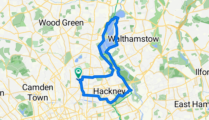
Sunday Hackney March
A cycling route starting in Islington, England, United Kingdom.
Overview
About this route
- -:--
- Duration
- 26.2 km
- Distance
- 48 m
- Ascent
- 49 m
- Descent
- ---
- Avg. speed
- ---
- Max. altitude

Route quality
Waytypes & surfaces along the route
Waytypes
Cycleway
12.6 km
(48 %)
Quiet road
7.6 km
(29 %)
Surfaces
Paved
22.8 km
(87 %)
Unpaved
1 km
(4 %)
Asphalt
22.3 km
(85 %)
Loose gravel
0.8 km
(3 %)
Continue with Bikemap
Use, edit, or download this cycling route
You would like to ride Sunday Hackney March or customize it for your own trip? Here is what you can do with this Bikemap route:
Free features
- Save this route as favorite or in collections
- Copy & plan your own version of this route
- Sync your route with Garmin or Wahoo
Premium features
Free trial for 3 days, or one-time payment. More about Bikemap Premium.
- Navigate this route on iOS & Android
- Export a GPX / KML file of this route
- Create your custom printout (try it for free)
- Download this route for offline navigation
Discover more Premium features.
Get Bikemap PremiumFrom our community
Other popular routes starting in Islington
 Sunday Hackney March
- Distance
- 26.2 km
- Ascent
- 48 m
- Descent
- 49 m
- Location
- Islington, England, United Kingdom
 Sunday Morning
- Distance
- 23.9 km
- Ascent
- 99 m
- Descent
- 98 m
- Location
- Islington, England, United Kingdom
 Rosemary Branch Haggerston return via Pitfield Street
- Distance
- 8.9 km
- Ascent
- 35 m
- Descent
- 47 m
- Location
- Islington, England, United Kingdom
 Monopoly
- Distance
- 32.7 km
- Ascent
- 137 m
- Descent
- 142 m
- Location
- Islington, England, United Kingdom
 PIZZA RIDE
- Distance
- 18.4 km
- Ascent
- 41 m
- Descent
- 49 m
- Location
- Islington, England, United Kingdom
 Political Waters in Ilinghton and Hackney
- Distance
- 15.4 km
- Ascent
- 51 m
- Descent
- 49 m
- Location
- Islington, England, United Kingdom
 London mish
- Distance
- 26.3 km
- Ascent
- 88 m
- Descent
- 86 m
- Location
- Islington, England, United Kingdom
 London Hobgoblin Ride
- Distance
- 39.5 km
- Ascent
- 145 m
- Descent
- 145 m
- Location
- Islington, England, United Kingdom
Open it in the app