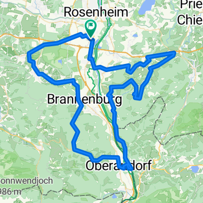
Der Große Samerberger
- 62.8 km
- 687 m
- 686 m
- Raubling, Bavaria, Germany
A cycling route starting in Raubling, Bavaria, Germany.
Overview
Big loop around and on the Samerberg with a detour to Simsee
This route around and on the Samerberg is dominated primarily by one element: the mountain! It is a constant up and down, only rarely can you ride relaxed on flat terrain.
The rider feels this after starting the tour in Kirchdorf, at the latest after Nußdorf, when riding through the quiet, cool and shady Mühlthal up to Holzmann and further to Duftbräu. Once there, the first big climb (up to 11% gradient) has been mastered.
Then follows a short, rapid descent via Hilgen down to Moosen. It is a pity that some of the elevation has to be regained up to Eßbaum! But as a warm-up for the second climb via Hundham up to Samerberg and Obereck, it is at least 'honest'.
At the top, reaching the "roof of the tour", it is recommended to take a corresponding, amazed break at the chapel at "Schönen Aussicht". Because with good visibility, the "world" truly lies at your feet: from Munich over Rosenheim, to Wasserburg and across to Chiemsee, the unspoiled panoramic view stretches. Unique!
Feeling "satisfied" like that, the good serpentine descent rolls down all the more relaxed to Achenmühle.
Immediately afterwards begins the often underestimated, extremely "tough" hilly landscape between Rosenheim and Chiemsee.
Through the stages Laiming, Söllhuben, Beuerberg and Riedering, the route is sometimes somewhat arduous and exhausting, constantly going up and down.
"All clear" can only be given again from Rohrdorf, as a relatively relaxed section follows back along the Inn to the starting point.
Continue with Bikemap
You would like to ride Der Große Samerberger or customize it for your own trip? Here is what you can do with this Bikemap route:
Free trial for 3 days, or one-time payment. More about Bikemap Premium.
Discover more Premium features.
Get Bikemap PremiumFrom our community
Open it in the app