

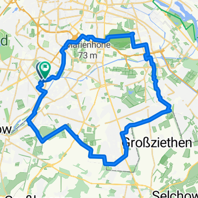
Lutterbacher Straße 9, Berlin to Lutterbacher Straße 9, Berlin
A cycling route starting in Lichterfelde, State of Berlin, Germany.
Overview
About this route
- 2 h 51 min
- Duration
- 48.2 km
- Distance
- 58 m
- Ascent
- 78 m
- Descent
- 16.9 km/h
- Avg. speed
- ---
- Max. altitude
Route quality
Waytypes & surfaces along the route
Waytypes
Path
11.6 km
(24 %)
Quiet road
9.2 km
(19 %)
Surfaces
Paved
31.3 km
(65 %)
Unpaved
10.6 km
(22 %)
Asphalt
27.9 km
(58 %)
Loose gravel
6.7 km
(14 %)
Continue with Bikemap
Use, edit, or download this cycling route
You would like to ride Lutterbacher Straße 9, Berlin to Lutterbacher Straße 9, Berlin or customize it for your own trip? Here is what you can do with this Bikemap route:
Free features
- Save this route as favorite or in collections
- Copy & plan your own version of this route
- Sync your route with Garmin or Wahoo
Premium features
Free trial for 3 days, or one-time payment. More about Bikemap Premium.
- Navigate this route on iOS & Android
- Export a GPX / KML file of this route
- Create your custom printout (try it for free)
- Download this route for offline navigation
Discover more Premium features.
Get Bikemap PremiumFrom our community
Other popular routes starting in Lichterfelde
 MTB-Runde Teltowkanal, Wannsee, Grunewald
- Distance
- 59.3 km
- Ascent
- 244 m
- Descent
- 243 m
- Location
- Lichterfelde, State of Berlin, Germany
 RTF Umland 70 km
- Distance
- 72 km
- Ascent
- 128 m
- Descent
- 125 m
- Location
- Lichterfelde, State of Berlin, Germany
 Route in Berlin
- Distance
- 32.4 km
- Ascent
- 134 m
- Descent
- 139 m
- Location
- Lichterfelde, State of Berlin, Germany
 B-908: LIF - THF
- Distance
- 10.1 km
- Ascent
- 37 m
- Descent
- 33 m
- Location
- Lichterfelde, State of Berlin, Germany
 Rundtour 1
- Distance
- 43.6 km
- Ascent
- 130 m
- Descent
- 132 m
- Location
- Lichterfelde, State of Berlin, Germany
 Schöne Griebnitzsee Tour
- Distance
- 32.7 km
- Ascent
- 101 m
- Descent
- 104 m
- Location
- Lichterfelde, State of Berlin, Germany
 Herbst im Wald
- Distance
- 20.6 km
- Ascent
- 50 m
- Descent
- 51 m
- Location
- Lichterfelde, State of Berlin, Germany
 Lange Ausfahrt durch Potsdam bis Werder
- Distance
- 70.8 km
- Ascent
- 119 m
- Descent
- 127 m
- Location
- Lichterfelde, State of Berlin, Germany
Open it in the app