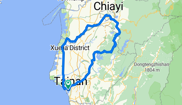
Two-day cycle: Tainan to Chiayi and back
A cycling route starting in Tainan City, Taiwan, Taiwan.
Overview
About this route
I completed this bicycle trip on the two days of a weekend: July 17-18, 2010. The first day of the journey was dull and uninspiring, a means to and end, that end being to get me to Chiayi from where I could spend the next day returning to Tainan via the foot-hill roads that run along the edges of the mountains behind WuShanTou Reservoir. Unfortunately I got myself a little bit sunburned on the way to Chiayi and so was paranoid about the skin damage getting any worse on the way back home. A mix of strategies reduced the potential harm of the ultra-violet radiation (including a small vial of SPF 50+ sunblock purchased from 7-11) and I arrived back at home in Tainan around 4:30 in the afternoon feeling weary but satisfied with my effort.
- -:--
- Duration
- 195.3 km
- Distance
- 820 m
- Ascent
- 817 m
- Descent
- ---
- Avg. speed
- ---
- Max. altitude
Route quality
Waytypes & surfaces along the route
Waytypes
Busy road
113.6 km
(58 %)
Access road
26.2 km
(13 %)
Surfaces
Paved
30.9 km
(16 %)
Asphalt
30.6 km
(16 %)
Paved (undefined)
0.3 km
(<1 %)
Route highlights
Points of interest along the route
Accommodation after 85.1 km
I stopped for the night here at a hotel on Zhongzheng Rd. At NT$800 for the night it was pretty basic but good enough after a long day's cycle. That rate included a complimentary breakfast (again quite basic) although I had to skip it in order to get away early.
Point of interest after 102.8 km
The nicest part of the journey. I rode over the bridge to the north-west of this point and suddenly found myself surrounded by pine trees. I think it was a plantation but the trees were very tall and underneath their thick canopy it was dark, damp, and cool; a real joy after cycling uphill with the morning sun already taking its toll in sweat.
Continue with Bikemap
Use, edit, or download this cycling route
You would like to ride Two-day cycle: Tainan to Chiayi and back or customize it for your own trip? Here is what you can do with this Bikemap route:
Free features
- Save this route as favorite or in collections
- Copy & plan your own version of this route
- Split it into stages to create a multi-day tour
- Sync your route with Garmin or Wahoo
Premium features
Free trial for 3 days, or one-time payment. More about Bikemap Premium.
- Navigate this route on iOS & Android
- Export a GPX / KML file of this route
- Create your custom printout (try it for free)
- Download this route for offline navigation
Discover more Premium features.
Get Bikemap PremiumFrom our community
Other popular routes starting in Tainan City
 鹽水溪畔西行至四草大橋對岸
- Distance
- 17.1 km
- Ascent
- 34 m
- Descent
- 27 m
- Location
- Tainan City, Taiwan, Taiwan
 台南─308高地
- Distance
- 72.2 km
- Ascent
- 466 m
- Descent
- 469 m
- Location
- Tainan City, Taiwan, Taiwan
 四草繞圈
四草繞圈- Distance
- 29.9 km
- Ascent
- 25 m
- Descent
- 28 m
- Location
- Tainan City, Taiwan, Taiwan
 201212/01-二寮行
- Distance
- 39.6 km
- Ascent
- 292 m
- Descent
- 292 m
- Location
- Tainan City, Taiwan, Taiwan
 單車ing至玉井
- Distance
- 75.6 km
- Ascent
- 264 m
- Descent
- 267 m
- Location
- Tainan City, Taiwan, Taiwan
 台南高鐵站至關廟森林公園
- Distance
- 25.7 km
- Ascent
- 115 m
- Descent
- 116 m
- Location
- Tainan City, Taiwan, Taiwan
 新化竹子腳(二)
- Distance
- 16.4 km
- Ascent
- 62 m
- Descent
- 61 m
- Location
- Tainan City, Taiwan, Taiwan
 6/29_Day5_台南-東港-住宿
- Distance
- 86.8 km
- Ascent
- 119 m
- Descent
- 141 m
- Location
- Tainan City, Taiwan, Taiwan
Open it in the app


