
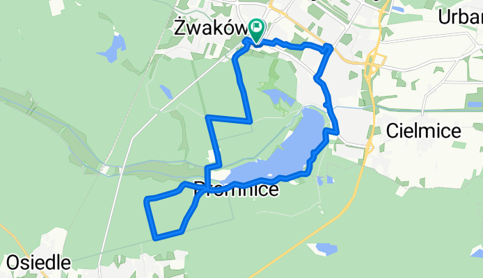
Cielmice Radfahren
A cycling route starting in Cielmice, Silesian Voivodeship, Poland.
Overview
About this route
- -:--
- Duration
- 14.4 km
- Distance
- 52 m
- Ascent
- 46 m
- Descent
- ---
- Avg. speed
- ---
- Max. altitude

Route quality
Waytypes & surfaces along the route
Waytypes
Track
5.5 km
(38 %)
Access road
3 km
(21 %)
Surfaces
Paved
2.2 km
(15 %)
Unpaved
5.3 km
(37 %)
Gravel
2.5 km
(17 %)
Ground
2.2 km
(15 %)
Continue with Bikemap
Use, edit, or download this cycling route
You would like to ride Cielmice Radfahren or customize it for your own trip? Here is what you can do with this Bikemap route:
Free features
- Save this route as favorite or in collections
- Copy & plan your own version of this route
- Sync your route with Garmin or Wahoo
Premium features
Free trial for 3 days, or one-time payment. More about Bikemap Premium.
- Navigate this route on iOS & Android
- Export a GPX / KML file of this route
- Create your custom printout (try it for free)
- Download this route for offline navigation
Discover more Premium features.
Get Bikemap PremiumFrom our community
Other popular routes starting in Cielmice
 Bike Atelier MTB Maraton 2016 - Tychy - PRO
- Distance
- 66.1 km
- Ascent
- 184 m
- Descent
- 184 m
- Location
- Cielmice, Silesian Voivodeship, Poland
 От Nad Jeziorem 34, Tychy до Nad Jeziorem 41, Tychy
- Distance
- 27.5 km
- Ascent
- 150 m
- Descent
- 138 m
- Location
- Cielmice, Silesian Voivodeship, Poland
 Tempo 30 - Rajsko
- Distance
- 58.4 km
- Ascent
- 117 m
- Descent
- 132 m
- Location
- Cielmice, Silesian Voivodeship, Poland
 Wincentego Witosa 8, Tychy do Wincentego Witosa 10, Tychy
- Distance
- 8.9 km
- Ascent
- 93 m
- Descent
- 97 m
- Location
- Cielmice, Silesian Voivodeship, Poland
 Cielmice Radfahren
- Distance
- 14.4 km
- Ascent
- 52 m
- Descent
- 46 m
- Location
- Cielmice, Silesian Voivodeship, Poland
 ostrava 31.05.2025
- Distance
- 89 km
- Ascent
- 395 m
- Descent
- 416 m
- Location
- Cielmice, Silesian Voivodeship, Poland
 Pszczyna pętla
- Distance
- 39.5 km
- Ascent
- 141 m
- Descent
- 134 m
- Location
- Cielmice, Silesian Voivodeship, Poland
 Moja trasa 4 /Pszczyna/
- Distance
- 36.1 km
- Ascent
- 134 m
- Descent
- 134 m
- Location
- Cielmice, Silesian Voivodeship, Poland
Open it in the app