

Vorschlag 2
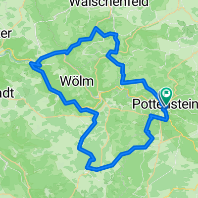
A cycling route starting in Pottenstein, Bavaria, Germany.
Overview
About this route
- -:--
- Duration
- 46.1 km
- Distance
- 642 m
- Ascent
- 644 m
- Descent
- ---
- Avg. speed
- ---
- Max. altitude
Route quality
Waytypes & surfaces along the route
Waytypes
Quiet road
17.9 km
(39 %)
Track
12.8 km
(28 %)
Surfaces
Paved
19.1 km
(41 %)
Unpaved
14.2 km
(31 %)
Asphalt
19 km
(41 %)
Gravel
12.4 km
(27 %)
Continue with Bikemap
Use, edit, or download this cycling route
You would like to ride Vorschlag 2 or customize it for your own trip? Here is what you can do with this Bikemap route:
Free features
- Save this route as favorite or in collections
- Copy & plan your own version of this route
- Sync your route with Garmin or Wahoo
Premium features
Free trial for 3 days, or one-time payment. More about Bikemap Premium.
- Navigate this route on iOS & Android
- Export a GPX / KML file of this route
- Create your custom printout (try it for free)
- Download this route for offline navigation
Discover more Premium features.
Get Bikemap PremiumFrom our community
Other popular routes starting in Pottenstein
 Unterwegs_Püttlachtal
- Distance
- 27.4 km
- Ascent
- 562 m
- Descent
- 563 m
- Location
- Pottenstein, Bavaria, Germany
 Pottenstein-Waldcafe-Aussichtsturm
- Distance
- 7.3 km
- Ascent
- 206 m
- Descent
- 209 m
- Location
- Pottenstein, Bavaria, Germany
 Pottenstein - Püttlachtal
- Distance
- 4.7 km
- Ascent
- 154 m
- Descent
- 108 m
- Location
- Pottenstein, Bavaria, Germany
 Pottenstein -> Erlangen (Rücktour) - Samstag 29.08.09
- Distance
- 53.3 km
- Ascent
- 505 m
- Descent
- 682 m
- Location
- Pottenstein, Bavaria, Germany
 Vorschlag 2
- Distance
- 46.1 km
- Ascent
- 642 m
- Descent
- 644 m
- Location
- Pottenstein, Bavaria, Germany
 Schiem-a-no.de: Tour2/Pottenstein – Weiße Marter
- Distance
- 39.1 km
- Ascent
- 618 m
- Descent
- 620 m
- Location
- Pottenstein, Bavaria, Germany
 KleinePot Pottenstein
- Distance
- 18.1 km
- Ascent
- 352 m
- Descent
- 350 m
- Location
- Pottenstein, Bavaria, Germany
 Dolomitsteilwände, Grotten und Höhlen
- Distance
- 15.9 km
- Ascent
- 341 m
- Descent
- 338 m
- Location
- Pottenstein, Bavaria, Germany
Open it in the app