
68m-Stilwater-Osceola
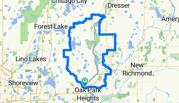
A cycling route starting in Stillwater, Minnesota, United States.
Overview
About this route
Copied from baude's Bikery Solstice century
- -:--
- Duration
- 110.2 km
- Distance
- 321 m
- Ascent
- 341 m
- Descent
- ---
- Avg. speed
- ---
- Max. altitude
Route quality
Waytypes & surfaces along the route
Waytypes
Busy road
42.3 km
(38 %)
Quiet road
33.2 km
(30 %)
Surfaces
Paved
57 km
(52 %)
Unpaved
2.1 km
(2 %)
Asphalt
53.5 km
(49 %)
Paved (undefined)
3.4 km
(3 %)
Continue with Bikemap
Use, edit, or download this cycling route
You would like to ride 68m-Stilwater-Osceola or customize it for your own trip? Here is what you can do with this Bikemap route:
Free features
- Save this route as favorite or in collections
- Copy & plan your own version of this route
- Split it into stages to create a multi-day tour
- Sync your route with Garmin or Wahoo
Premium features
Free trial for 3 days, or one-time payment. More about Bikemap Premium.
- Navigate this route on iOS & Android
- Export a GPX / KML file of this route
- Create your custom printout (try it for free)
- Download this route for offline navigation
Discover more Premium features.
Get Bikemap PremiumFrom our community
Other popular routes starting in Stillwater
 St. Croix River Crossing Loop Trail
- Distance
- 8.4 km
- Ascent
- 123 m
- Descent
- 123 m
- Location
- Stillwater, Minnesota, United States
 B2B00869 55082>55014 viaStillwaterRd/75thSt/GatewayTrail/WheelockPkwy/Como/EnergyPk CLONED FROM ROUTE 75356
- Distance
- 32.5 km
- Ascent
- 140 m
- Descent
- 140 m
- Location
- Stillwater, Minnesota, United States
 Stillwater to Hostel Shoppe, Stevens Point, WI
- Distance
- 353.2 km
- Ascent
- 1,346 m
- Descent
- 1,225 m
- Location
- Stillwater, Minnesota, United States
 B2B00202 55082>55408viaHwy96,Gateway,Como,Greenway
- Distance
- 48.6 km
- Ascent
- 223 m
- Descent
- 182 m
- Location
- Stillwater, Minnesota, United States
 Brown's Creek State Trail, Stillwater to Brown's Creek State Trail, Stillwater
- Distance
- 21.4 km
- Ascent
- 142 m
- Descent
- 144 m
- Location
- Stillwater, Minnesota, United States
 B2B00869 55082>55014 viaStillwaterRd/75thSt/GatewayTrail/WheelockPkwy/Como/EnergyPk
- Distance
- 32.5 km
- Ascent
- 114 m
- Descent
- 119 m
- Location
- Stillwater, Minnesota, United States
 Stillwater, MN to Woodville, WI
- Distance
- 52.7 km
- Ascent
- 275 m
- Descent
- 139 m
- Location
- Stillwater, Minnesota, United States
 B2B00867 55082>55402 via StillwaterRd75thStN/GatewayTrail/WheelockPkwy/Como/Intercampus/4thSE/StoneArch/3rdAv
- Distance
- 41.7 km
- Ascent
- 160 m
- Descent
- 177 m
- Location
- Stillwater, Minnesota, United States
Open it in the app