

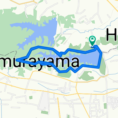
多摩湖からの帰り路
A cycling route starting in Higashimurayama, Tokyo, Japan.
Overview
About this route
- 1 h 11 min
- Duration
- 14.6 km
- Distance
- 84 m
- Ascent
- 146 m
- Descent
- 12.4 km/h
- Avg. speed
- ---
- Max. altitude

Route photos


Continue with Bikemap
Use, edit, or download this cycling route
You would like to ride 多摩湖からの帰り路 or customize it for your own trip? Here is what you can do with this Bikemap route:
Free features
- Save this route as favorite or in collections
- Copy & plan your own version of this route
- Sync your route with Garmin or Wahoo
Premium features
Free trial for 3 days, or one-time payment. More about Bikemap Premium.
- Navigate this route on iOS & Android
- Export a GPX / KML file of this route
- Create your custom printout (try it for free)
- Download this route for offline navigation
Discover more Premium features.
Get Bikemap PremiumFrom our community
Other popular routes starting in Higashimurayama
 Ruta tranquila en Koganei-Shi
- Distance
- 6.3 km
- Ascent
- 0 m
- Descent
- 13 m
- Location
- Higashimurayama, Tokyo, Japan
 Tamako Lake 9 jul 17
- Distance
- 8 km
- Ascent
- 103 m
- Descent
- 105 m
- Location
- Higashimurayama, Tokyo, Japan
 2丁目 1, 東村山市 to 鴻巣市
- Distance
- 55.9 km
- Ascent
- 6 m
- Descent
- 45 m
- Location
- Higashimurayama, Tokyo, Japan
 Start to Nikko
- Distance
- 140.2 km
- Ascent
- 552 m
- Descent
- 96 m
- Location
- Higashimurayama, Tokyo, Japan
 3丁目, 東大和市 まで2丁目 12, 川口市
- Distance
- 34.6 km
- Ascent
- 66 m
- Descent
- 145 m
- Location
- Higashimurayama, Tokyo, Japan
 3丁目 2, 小平市 まで7丁目 1, 小平市
- Distance
- 0.6 km
- Ascent
- 4 m
- Descent
- 0 m
- Location
- Higashimurayama, Tokyo, Japan
 Tamako
- Distance
- 37.6 km
- Ascent
- 209 m
- Descent
- 209 m
- Location
- Higashimurayama, Tokyo, Japan
 2705−43, 所沢市 to 2705−43, 所沢市
- Distance
- 51.1 km
- Ascent
- 536 m
- Descent
- 521 m
- Location
- Higashimurayama, Tokyo, Japan
Open it in the app