

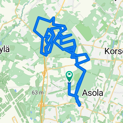
Keihästie 34, Vantaa nach Rantakyläntie 19, Sipoo
A cycling route starting in Vantaa, Uusimaa, Finland.
Overview
About this route
- 1 h 3 min
- Duration
- 17.5 km
- Distance
- 116 m
- Ascent
- 138 m
- Descent
- 16.7 km/h
- Avg. speed
- ---
- Max. altitude

Route quality
Waytypes & surfaces along the route
Waytypes
Cycleway
12.2 km
(70 %)
Road
2.4 km
(14 %)
Surfaces
Paved
17 km
(97 %)
Asphalt
12.4 km
(71 %)
Paved (undefined)
4.5 km
(26 %)
Undefined
0.5 km
(3 %)
Continue with Bikemap
Use, edit, or download this cycling route
You would like to ride Keihästie 34, Vantaa nach Rantakyläntie 19, Sipoo or customize it for your own trip? Here is what you can do with this Bikemap route:
Free features
- Save this route as favorite or in collections
- Copy & plan your own version of this route
- Sync your route with Garmin or Wahoo
Premium features
Free trial for 3 days, or one-time payment. More about Bikemap Premium.
- Navigate this route on iOS & Android
- Export a GPX / KML file of this route
- Create your custom printout (try it for free)
- Download this route for offline navigation
Discover more Premium features.
Get Bikemap PremiumFrom our community
Other popular routes starting in Vantaa
 Säveltie, Vantaa to Säveltie, Vantaa
- Distance
- 35.4 km
- Ascent
- 582 m
- Descent
- 580 m
- Location
- Vantaa, Uusimaa, Finland
 Vuosaari towards Porvoo
- Distance
- 54.8 km
- Ascent
- 209 m
- Descent
- 207 m
- Location
- Vantaa, Uusimaa, Finland
 Mäkilenkki
- Distance
- 55.8 km
- Ascent
- 318 m
- Descent
- 318 m
- Location
- Vantaa, Uusimaa, Finland
 ride through Vantaa silvola
- Distance
- 17.8 km
- Ascent
- 0 m
- Descent
- 0 m
- Location
- Vantaa, Uusimaa, Finland
 Suomantie, Vantaa to Suomantie, Vantaa
- Distance
- 9.4 km
- Ascent
- 140 m
- Descent
- 148 m
- Location
- Vantaa, Uusimaa, Finland
 Läksyrinne 113
- Distance
- 112.8 km
- Ascent
- 254 m
- Descent
- 254 m
- Location
- Vantaa, Uusimaa, Finland
 Camping - Ferry naar city center
- Distance
- 10.8 km
- Ascent
- 10 m
- Descent
- 13 m
- Location
- Vantaa, Uusimaa, Finland
 Tammistonkatu, Vantaa to Puutarhatie, Vantaa
- Distance
- 28.8 km
- Ascent
- 511 m
- Descent
- 503 m
- Location
- Vantaa, Uusimaa, Finland
Open it in the app