

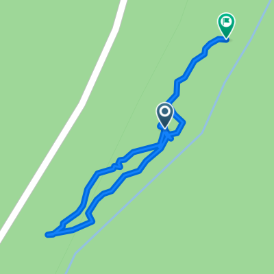
sandy creek trail
A cycling route starting in Seneca, Pennsylvania, United States.
Overview
About this route
- -:--
- Duration
- 20.3 km
- Distance
- 310 m
- Ascent
- 395 m
- Descent
- ---
- Avg. speed
- ---
- Max. altitude
Route quality
Waytypes & surfaces along the route
Waytypes
Cycleway
19.5 km
(96 %)
Path
0.8 km
(4 %)
Surfaces
Paved
19.5 km
(96 %)
Unpaved
0.8 km
(4 %)
Asphalt
18.7 km
(92 %)
Wood
0.8 km
(4 %)
Ground
0.8 km
(4 %)
Continue with Bikemap
Use, edit, or download this cycling route
You would like to ride sandy creek trail or customize it for your own trip? Here is what you can do with this Bikemap route:
Free features
- Save this route as favorite or in collections
- Copy & plan your own version of this route
- Sync your route with Garmin or Wahoo
Premium features
Free trial for 3 days, or one-time payment. More about Bikemap Premium.
- Navigate this route on iOS & Android
- Export a GPX / KML file of this route
- Create your custom printout (try it for free)
- Download this route for offline navigation
Discover more Premium features.
Get Bikemap PremiumFrom our community
Other popular routes starting in Seneca
 sandy creek trail
- Distance
- 20.3 km
- Ascent
- 310 m
- Descent
- 395 m
- Location
- Seneca, Pennsylvania, United States
 Restful route
- Distance
- 26.8 km
- Ascent
- 839 m
- Descent
- 849 m
- Location
- Seneca, Pennsylvania, United States
 Freedom Falls and Furnace
- Distance
- 0.9 km
- Ascent
- 68 m
- Descent
- 44 m
- Location
- Seneca, Pennsylvania, United States
 Kennerdell to 4566–4570 Lakes to the Sea Hwy, Franklin
- Distance
- 9 km
- Ascent
- 35 m
- Descent
- 33 m
- Location
- Seneca, Pennsylvania, United States
 sandy creek rockland to fishermans cove
- Distance
- 23.7 km
- Ascent
- 273 m
- Descent
- 270 m
- Location
- Seneca, Pennsylvania, United States
 Tarklin Hill Rd, Cranberry to Tarklin Hill Rd, Cranberry
- Distance
- 25.3 km
- Ascent
- 275 m
- Descent
- 271 m
- Location
- Seneca, Pennsylvania, United States
Open it in the app