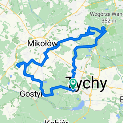
?$ZŸ? do ?$ZŸ?
A cycling route starting in Tychy, Silesian Voivodeship, Poland.
Overview
About this route
- 1 h 50 min
- Duration
- 26.9 km
- Distance
- 1,014 m
- Ascent
- 1,028 m
- Descent
- 14.6 km/h
- Avg. speed
- ---
- Max. altitude
Continue with Bikemap
Use, edit, or download this cycling route
You would like to ride ?$ZŸ? do ?$ZŸ? or customize it for your own trip? Here is what you can do with this Bikemap route:
Free features
- Save this route as favorite or in collections
- Copy & plan your own version of this route
- Sync your route with Garmin or Wahoo
Premium features
Free trial for 3 days, or one-time payment. More about Bikemap Premium.
- Navigate this route on iOS & Android
- Export a GPX / KML file of this route
- Create your custom printout (try it for free)
- Download this route for offline navigation
Discover more Premium features.
Get Bikemap PremiumFrom our community
Other popular routes starting in Tychy
- Tychy - Mikolow - Katowice - Tychy
- Distance
- 44.8 km
- Ascent
- 309 m
- Descent
- 307 m
- Location
- Tychy, Silesian Voivodeship, Poland
- Polskie Sanktuaria Maryjne
- Distance
- 1,832.3 km
- Ascent
- 760 m
- Descent
- 760 m
- Location
- Tychy, Silesian Voivodeship, Poland
- tychy - ustron rownica - tychy
- Distance
- 141.8 km
- Ascent
- 616 m
- Descent
- 617 m
- Location
- Tychy, Silesian Voivodeship, Poland
- Tychy - Pszczyna - Ustroń - Wisła
- Distance
- 64.9 km
- Ascent
- 429 m
- Descent
- 264 m
- Location
- Tychy, Silesian Voivodeship, Poland
- Tychy - strusia ferma - Tychy
- Distance
- 43.2 km
- Ascent
- 103 m
- Descent
- 112 m
- Location
- Tychy, Silesian Voivodeship, Poland
- Szlakiem rezerwatów przyrody
- Distance
- 44.8 km
- Ascent
- 239 m
- Descent
- 240 m
- Location
- Tychy, Silesian Voivodeship, Poland
- kamien
- Distance
- 33.9 km
- Ascent
- 149 m
- Descent
- 137 m
- Location
- Tychy, Silesian Voivodeship, Poland
- trasa 15.08.19
- Distance
- 38.8 km
- Ascent
- 175 m
- Descent
- 172 m
- Location
- Tychy, Silesian Voivodeship, Poland
Open it in the app