

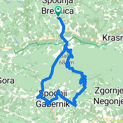
Loče - Ribniki Jernej - Lubicno - Loče
A cycling route starting in Poljčane, Občina Poljčane, Slovenia.
Overview
About this route
Nice easy MTB tour, ascent to Lubično on the road, descent on the mountain trail.
- -:--
- Duration
- 17 km
- Distance
- 368 m
- Ascent
- 369 m
- Descent
- ---
- Avg. speed
- ---
- Max. altitude

Route quality
Waytypes & surfaces along the route
Waytypes
Quiet road
6.8 km
(40 %)
Track
4.1 km
(24 %)
Surfaces
Paved
10.7 km
(63 %)
Unpaved
6 km
(35 %)
Asphalt
10.7 km
(63 %)
Ground
4.6 km
(27 %)
Continue with Bikemap
Use, edit, or download this cycling route
You would like to ride Loče - Ribniki Jernej - Lubicno - Loče or customize it for your own trip? Here is what you can do with this Bikemap route:
Free features
- Save this route as favorite or in collections
- Copy & plan your own version of this route
- Sync your route with Garmin or Wahoo
Premium features
Free trial for 3 days, or one-time payment. More about Bikemap Premium.
- Navigate this route on iOS & Android
- Export a GPX / KML file of this route
- Create your custom printout (try it for free)
- Download this route for offline navigation
Discover more Premium features.
Get Bikemap PremiumFrom our community
Other popular routes starting in Poljčane
 Okoli Boča
- Distance
- 23.1 km
- Ascent
- 932 m
- Descent
- 936 m
- Location
- Poljčane, Občina Poljčane, Slovenia
 MTB: Poljčane - Boč (Stolp)
- Distance
- 26.2 km
- Ascent
- 934 m
- Descent
- 938 m
- Location
- Poljčane, Občina Poljčane, Slovenia
 okoli Boča s podaljškom do Podčetrtka
- Distance
- 76.9 km
- Ascent
- 363 m
- Descent
- 370 m
- Location
- Poljčane, Občina Poljčane, Slovenia
 krog do Maribora
- Distance
- 71.2 km
- Ascent
- 235 m
- Descent
- 232 m
- Location
- Poljčane, Občina Poljčane, Slovenia
 čez Boč iz Kostrivnice
- Distance
- 23.2 km
- Ascent
- 585 m
- Descent
- 589 m
- Location
- Poljčane, Občina Poljčane, Slovenia
 Poljčane - Zavrč
- Distance
- 54.4 km
- Ascent
- 411 m
- Descent
- 470 m
- Location
- Poljčane, Občina Poljčane, Slovenia
 čez Boč
- Distance
- 31.3 km
- Ascent
- 688 m
- Descent
- 691 m
- Location
- Poljčane, Občina Poljčane, Slovenia
 Tur po Sloveniji I
- Distance
- 355.2 km
- Ascent
- 3,896 m
- Descent
- 3,885 m
- Location
- Poljčane, Občina Poljčane, Slovenia
Open it in the app