

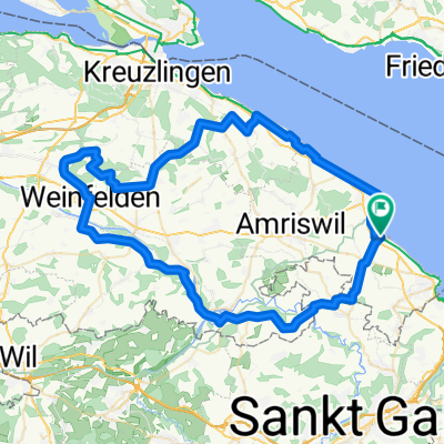
A1.1, Roggwil (TG) to Buchhorn 47, Arbon
A cycling route starting in Egnach, Thurgau, Switzerland.
Overview
About this route
- 2 h 13 min
- Duration
- 18.9 km
- Distance
- 373 m
- Ascent
- 389 m
- Descent
- 8.5 km/h
- Avg. speed
- ---
- Max. altitude
Route quality
Waytypes & surfaces along the route
Waytypes
Track
8.7 km
(46 %)
Quiet road
4.1 km
(22 %)
Surfaces
Paved
7.5 km
(40 %)
Unpaved
6.2 km
(33 %)
Asphalt
5.3 km
(28 %)
Unpaved (undefined)
2.8 km
(15 %)
Continue with Bikemap
Use, edit, or download this cycling route
You would like to ride A1.1, Roggwil (TG) to Buchhorn 47, Arbon or customize it for your own trip? Here is what you can do with this Bikemap route:
Free features
- Save this route as favorite or in collections
- Copy & plan your own version of this route
- Sync your route with Garmin or Wahoo
Premium features
Free trial for 3 days, or one-time payment. More about Bikemap Premium.
- Navigate this route on iOS & Android
- Export a GPX / KML file of this route
- Create your custom printout (try it for free)
- Download this route for offline navigation
Discover more Premium features.
Get Bikemap PremiumFrom our community
Other popular routes starting in Egnach
 1 Egnach Sittertobel Bischofszell
- Distance
- 17.2 km
- Ascent
- 232 m
- Descent
- 130 m
- Location
- Egnach, Thurgau, Switzerland
 Romanshornerstrasse 105B, Egnach nach Romanshornerstrasse 105F, Egnach
- Distance
- 3 km
- Ascent
- 45 m
- Descent
- 0 m
- Location
- Egnach, Thurgau, Switzerland
 Obstgärten + See
- Distance
- 72.4 km
- Ascent
- 583 m
- Descent
- 583 m
- Location
- Egnach, Thurgau, Switzerland
 Route Mittelland (Egnach/Romanshorn - Baden)
- Distance
- 118.8 km
- Ascent
- 535 m
- Descent
- 554 m
- Location
- Egnach, Thurgau, Switzerland
 4. Etappe Bodensee Romanshorn - Stein am Rhein
- Distance
- 54.2 km
- Ascent
- 207 m
- Descent
- 213 m
- Location
- Egnach, Thurgau, Switzerland
 heuhotel zum Bf Romanshorn
- Distance
- 6 km
- Ascent
- 10 m
- Descent
- 18 m
- Location
- Egnach, Thurgau, Switzerland
 Egnach - Friedrichhafen
- Distance
- 72.9 km
- Ascent
- 270 m
- Descent
- 280 m
- Location
- Egnach, Thurgau, Switzerland
 Am Wilerbach 8, Egnach nach Am Wilerbach 8, Egnach
- Distance
- 33.4 km
- Ascent
- 186 m
- Descent
- 186 m
- Location
- Egnach, Thurgau, Switzerland
Open it in the app