

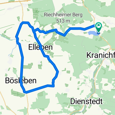
Gemütliche Route in Tonndorf
A cycling route starting in Tonndorf, Free State of Thuringia, Germany.
Overview
About this route
- 45 min
- Duration
- 8.1 km
- Distance
- 463 m
- Ascent
- 478 m
- Descent
- 10.8 km/h
- Avg. speed
- ---
- Max. altitude
Continue with Bikemap
Use, edit, or download this cycling route
You would like to ride Gemütliche Route in Tonndorf or customize it for your own trip? Here is what you can do with this Bikemap route:
Free features
- Save this route as favorite or in collections
- Copy & plan your own version of this route
- Sync your route with Garmin or Wahoo
Premium features
Free trial for 3 days, or one-time payment. More about Bikemap Premium.
- Navigate this route on iOS & Android
- Export a GPX / KML file of this route
- Create your custom printout (try it for free)
- Download this route for offline navigation
Discover more Premium features.
Get Bikemap PremiumFrom our community
Other popular routes starting in Tonndorf
 Avenida Therme - Erfurt
- Distance
- 22.8 km
- Ascent
- 198 m
- Descent
- 318 m
- Location
- Tonndorf, Free State of Thuringia, Germany
 Hohenfelden Stausee-Klettbach-Riechheimer Berg-Kletterwald Hohenfelden Stausee
- Distance
- 18.9 km
- Ascent
- 294 m
- Descent
- 297 m
- Location
- Tonndorf, Free State of Thuringia, Germany
 Von der Avenida-Therme über den Windberg
- Distance
- 22.9 km
- Ascent
- 342 m
- Descent
- 345 m
- Location
- Tonndorf, Free State of Thuringia, Germany
 Avenida Therma - Weimar
- Distance
- 23.6 km
- Ascent
- 198 m
- Descent
- 299 m
- Location
- Tonndorf, Free State of Thuringia, Germany
 Dienstedt
- Distance
- 38.8 km
- Ascent
- 533 m
- Descent
- 518 m
- Location
- Tonndorf, Free State of Thuringia, Germany
 Triathlon Erfurt 40 km Runde
- Distance
- 40.2 km
- Ascent
- 373 m
- Descent
- 373 m
- Location
- Tonndorf, Free State of Thuringia, Germany
 Gemütliche Route in Tonndorf
- Distance
- 8.1 km
- Ascent
- 463 m
- Descent
- 478 m
- Location
- Tonndorf, Free State of Thuringia, Germany
 Avenida Therma - München (Bad Berka)
- Distance
- 6.1 km
- Ascent
- 43 m
- Descent
- 80 m
- Location
- Tonndorf, Free State of Thuringia, Germany
Open it in the app