

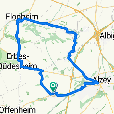
Alzey - Rossmarktbrunnen, 4,5 km, 40 hm
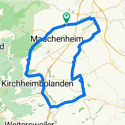
A cycling route starting in Mauchenheim, Rhineland-Palatinate, Germany.
Overview
About this route
- -:--
- Duration
- 4.2 km
- Distance
- 23 m
- Ascent
- 63 m
- Descent
- ---
- Avg. speed
- ---
- Max. altitude
Route quality
Waytypes & surfaces along the route
Waytypes
Path
2.4 km
(58 %)
Quiet road
0.6 km
(14 %)
Surfaces
Paved
3.5 km
(83 %)
Unpaved
0.5 km
(13 %)
Paving stones
2.2 km
(53 %)
Asphalt
0.9 km
(21 %)
Continue with Bikemap
Use, edit, or download this cycling route
You would like to ride Alzey - Rossmarktbrunnen, 4,5 km, 40 hm or customize it for your own trip? Here is what you can do with this Bikemap route:
Free features
- Save this route as favorite or in collections
- Copy & plan your own version of this route
- Sync your route with Garmin or Wahoo
Premium features
Free trial for 3 days, or one-time payment. More about Bikemap Premium.
- Navigate this route on iOS & Android
- Export a GPX / KML file of this route
- Create your custom printout (try it for free)
- Download this route for offline navigation
Discover more Premium features.
Get Bikemap PremiumFrom our community
Other popular routes starting in Mauchenheim
 Alzey - Rundweg, 35 km, 150 hm
- Distance
- 34.3 km
- Ascent
- 112 m
- Descent
- 152 m
- Location
- Mauchenheim, Rhineland-Palatinate, Germany
 Kirchheimbolanden
- Distance
- 11.5 km
- Ascent
- 140 m
- Descent
- 87 m
- Location
- Mauchenheim, Rhineland-Palatinate, Germany
 Alzey 2 Hiwwelroute
- Distance
- 22.1 km
- Ascent
- 248 m
- Descent
- 247 m
- Location
- Mauchenheim, Rhineland-Palatinate, Germany
 Alzey - Weingut Listmann, 22 km, 140 hm
- Distance
- 21.2 km
- Ascent
- 115 m
- Descent
- 151 m
- Location
- Mauchenheim, Rhineland-Palatinate, Germany
 Schön Wetter Runde
- Distance
- 75.5 km
- Ascent
- 823 m
- Descent
- 836 m
- Location
- Mauchenheim, Rhineland-Palatinate, Germany
 Rieslingweg 42, Alzey nach Kirchheimbolanden
- Distance
- 36.8 km
- Ascent
- 660 m
- Descent
- 607 m
- Location
- Mauchenheim, Rhineland-Palatinate, Germany
 Kurze Runde
- Distance
- 39.9 km
- Ascent
- 401 m
- Descent
- 399 m
- Location
- Mauchenheim, Rhineland-Palatinate, Germany
 Kurze Runde CLONED FROM ROUTE 82258
- Distance
- 40 km
- Ascent
- 397 m
- Descent
- 398 m
- Location
- Mauchenheim, Rhineland-Palatinate, Germany
Open it in the app