Premium Badge Download on the App Store Get it on Google Play Turn-by-turn Navigation Offline Maps Bike Type Optimized Routing Premium Maps Custom Bike Computer Export Routes Route Previews Fall Detection Premium Support

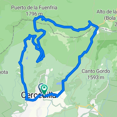
Cycling Route in Cercedilla, Madrid, Spain

Cercedilla - Fuenfría - Alto Los Leones - Cercedilla

0
Open this route in the Bikemap app

Open this route in the Bikemap app

Open this route in Bikemap Web

Open this route in Bikemap Web

44 km
Distance
1020 m
Ascent
1020 m
Descent
-:-- h
Duration
-- km/h
Avg. Speed
--- m
Max. Elevation

About This Route

Salimos de la Estación de Cercedilla, tomamos la ctra de la República, subimos a la Fuenfría, tomamos el camino a la izda. del que baja a Segovia. A unos 4 km, a la drcha. aparece un muro de piedra con una puerta, la atravesamos; frente a la puerta baja un sendero hasta el camino siguiente. Todo recto hasta la siguiente puerta. Pasamos la puerta y seguimos los caminos que salen a la izda. Llegamos hasta la N-VI. Subimos hasta el Alto del León. Bajamos aprox. 1 km del puerto por la ctra., en el arcén drcho. aparece un mojón de pidras, tomamos ese camino de vuelta a Cercedilla.

This cycling route is ideal for: MTB

You will cycle on the following surfaces: Unpaved Gravel

Customize this cycling route with the Bikemap route planner.

Make it yours!

Did you know? You can use this route as a template in our cycling route planner if you don't wish to start from scratch. Customize it based on your needs to plan your perfect cycling tour.

Open it in the app