

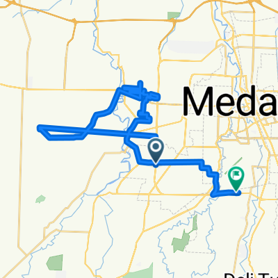
Jalan Penampungan, Kecamatan Sunggal to Jalan Penampungan, Kecamatan Sunggal
A cycling route starting in Sunggal, North Sumatra, Indonesia.
Overview
About this route
- 4 h 31 min
- Duration
- 30.8 km
- Distance
- 468 m
- Ascent
- 464 m
- Descent
- 6.8 km/h
- Avg. speed
- ---
- Max. altitude

Route photos


Continue with Bikemap
Use, edit, or download this cycling route
You would like to ride Jalan Penampungan, Kecamatan Sunggal to Jalan Penampungan, Kecamatan Sunggal or customize it for your own trip? Here is what you can do with this Bikemap route:
Free features
- Save this route as favorite or in collections
- Copy & plan your own version of this route
- Sync your route with Garmin or Wahoo
Premium features
Free trial for 3 days, or one-time payment. More about Bikemap Premium.
- Navigate this route on iOS & Android
- Export a GPX / KML file of this route
- Create your custom printout (try it for free)
- Download this route for offline navigation
Discover more Premium features.
Get Bikemap PremiumFrom our community
Other popular routes starting in Sunggal
 Jalan Jati 4, Kecamatan Sunggal to Jalan Jati 11, Kecamatan Sunggal
- Distance
- 28.4 km
- Ascent
- 99 m
- Descent
- 67 m
- Location
- Sunggal, North Sumatra, Indonesia
 RMOSP 21/08/25
- Distance
- 41 km
- Ascent
- 284 m
- Descent
- 274 m
- Location
- Sunggal, North Sumatra, Indonesia
 Jalan Setia Budi 643DD to Pangkalan Masyhur
- Distance
- 25.2 km
- Ascent
- 214 m
- Descent
- 205 m
- Location
- Sunggal, North Sumatra, Indonesia
 Jalan Amal 32d, Kecamatan Medan Sunggal to Jalan Flamboyan IIA No.17h, Kecamatan Medan Tuntungan
- Distance
- 7.3 km
- Ascent
- 47 m
- Descent
- 30 m
- Location
- Sunggal, North Sumatra, Indonesia
 Jalan Gaperta Ujung No.5a, Kecamatan Medan Helvetia to Jalan Tahi Bonar Simatupang 43, Kecamatan Medan Sunggal
- Distance
- 33.9 km
- Ascent
- 81 m
- Descent
- 80 m
- Location
- Sunggal, North Sumatra, Indonesia
 Jalan Penampungan, Kecamatan Sunggal to Jalan Penampungan, Kecamatan Sunggal
- Distance
- 30.8 km
- Ascent
- 468 m
- Descent
- 464 m
- Location
- Sunggal, North Sumatra, Indonesia
 Jalan Bunga Raya to Jalan Jenderal Besar A.H. Nasution No.9
- Distance
- 59.3 km
- Ascent
- 668 m
- Descent
- 644 m
- Location
- Sunggal, North Sumatra, Indonesia
 Jalan Perjuangan, Kecamatan Sunggal to Jalan Lembaga Pemasyarakatan No.12, Kecamatan Sunggal
- Distance
- 28.8 km
- Ascent
- 94 m
- Descent
- 94 m
- Location
- Sunggal, North Sumatra, Indonesia
Open it in the app