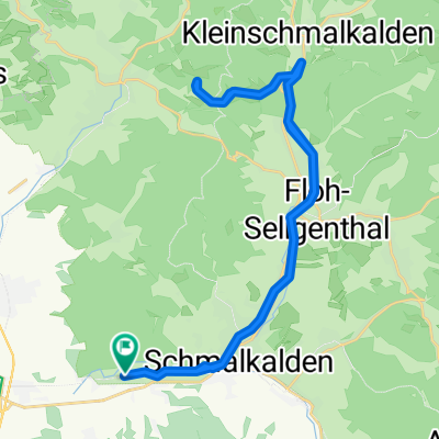
SM - Heuberg - Ebertswiese - SM
A cycling route starting in Schmalkalden, Thuringia, Germany.
Overview
About this route
- -:--
- Duration
- 34.9 km
- Distance
- 534 m
- Ascent
- 536 m
- Descent
- ---
- Avg. speed
- ---
- Max. altitude
Route quality
Waytypes & surfaces along the route
Waytypes
Cycleway
9.8 km
(28 %)
Quiet road
8 km
(23 %)
Surfaces
Paved
26.9 km
(77 %)
Unpaved
6.3 km
(18 %)
Asphalt
26.9 km
(77 %)
Gravel
4.9 km
(14 %)
Continue with Bikemap
Use, edit, or download this cycling route
You would like to ride SM - Heuberg - Ebertswiese - SM or customize it for your own trip? Here is what you can do with this Bikemap route:
Free features
- Save this route as favorite or in collections
- Copy & plan your own version of this route
- Sync your route with Garmin or Wahoo
Premium features
Free trial for 3 days, or one-time payment. More about Bikemap Premium.
- Navigate this route on iOS & Android
- Export a GPX / KML file of this route
- Create your custom printout (try it for free)
- Download this route for offline navigation
Discover more Premium features.
Get Bikemap PremiumFrom our community
Other popular routes starting in Schmalkalden
- Dolmarrunde
- Distance
- 32.7 km
- Ascent
- 669 m
- Descent
- 666 m
- Location
- Schmalkalden, Thuringia, Germany
- SM - Heuberg - Ebertswiese - SM
- Distance
- 34.9 km
- Ascent
- 534 m
- Descent
- 536 m
- Location
- Schmalkalden, Thuringia, Germany
- Allendestraße 71, Schmalkalden nach An der Asbacher Straße 18, Schmalkalden
- Distance
- 184.3 km
- Ascent
- 1,865 m
- Descent
- 1,897 m
- Location
- Schmalkalden, Thuringia, Germany
- Mittelstille - Kleiner Dolmar - Christes - Metzels - Walldorf - Werratalweg - Wernshausen - Schmalkalden
- Distance
- 46.2 km
- Ascent
- 455 m
- Descent
- 456 m
- Location
- Schmalkalden, Thuringia, Germany
- Eisenach
- Distance
- 41.7 km
- Ascent
- 411 m
- Descent
- 503 m
- Location
- Schmalkalden, Thuringia, Germany
- 2017-09-02: Schmalkalden - Floh-Seligental - Brotterode - Inselsberg - Immelborn - Breitungen
- Distance
- 77.3 km
- Ascent
- 753 m
- Descent
- 749 m
- Location
- Schmalkalden, Thuringia, Germany
- Schmalkalden-Rennsteig-Ebertswiese-Schmalkalden
- Distance
- 29.4 km
- Ascent
- 919 m
- Descent
- 919 m
- Location
- Schmalkalden, Thuringia, Germany
- 170902_Schmalkalden-Mom-REN-Tan-WTR-Mom
- Distance
- 77.2 km
- Ascent
- 681 m
- Descent
- 679 m
- Location
- Schmalkalden, Thuringia, Germany
Open it in the app