

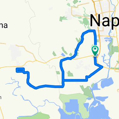
Route des vins - Wine Ride (Napa Valley)
A cycling route starting in Napa, California, United States of America.
Overview
About this route
Idéalement en 2 jours avec une nuitée à St Helena ou Calistoga (alternative) car vous allez déguster du vin tout au long de ce circuit plat. Il y a des vignobles pour y passer une semaine complète mais vous trouverez sur la carte une sélection des arrêts les plus intéressants (Ex. Mumm et Beringer) incluant quelques producteurs d'huile d'olive. La Wine Pass est recommandée et certains B&B l'inclut dans le prix de votre séjour.
- -:--
- Duration
- 63.5 km
- Distance
- 149 m
- Ascent
- 152 m
- Descent
- ---
- Avg. speed
- ---
- Max. altitude

Route quality
Waytypes & surfaces along the route
Waytypes
Busy road
32.7 km
(52 %)
Access road
14 km
(22 %)
Surfaces
Paved
26.4 km
(42 %)
Asphalt
26.4 km
(42 %)
Undefined
37.1 km
(58 %)
Continue with Bikemap
Use, edit, or download this cycling route
You would like to ride Route des vins - Wine Ride (Napa Valley) or customize it for your own trip? Here is what you can do with this Bikemap route:
Free features
- Save this route as favorite or in collections
- Copy & plan your own version of this route
- Sync your route with Garmin or Wahoo
Premium features
Free trial for 3 days, or one-time payment. More about Bikemap Premium.
- Navigate this route on iOS & Android
- Export a GPX / KML file of this route
- Create your custom printout (try it for free)
- Download this route for offline navigation
Discover more Premium features.
Get Bikemap PremiumFrom our community
Other popular routes starting in Napa
 oil. change, goat,Mnt Tram, Raleigh- jfk oxbo
- Distance
- 18.9 km
- Ascent
- 61 m
- Descent
- 61 m
- Location
- Napa, California, United States of America
 Napa to Yountville
- Distance
- 57.1 km
- Ascent
- 145 m
- Descent
- 145 m
- Location
- Napa, California, United States of America
 Napa to Sonoma
- Distance
- 24.2 km
- Ascent
- 178 m
- Descent
- 166 m
- Location
- Napa, California, United States of America
 Napa to Calistoga
- Distance
- 41.3 km
- Ascent
- 198 m
- Descent
- 102 m
- Location
- Napa, California, United States of America
 Escape, brooks swift, breakin1-
- Distance
- 24.2 km
- Ascent
- 380 m
- Descent
- 381 m
- Location
- Napa, California, United States of America
 Stanly/Carneros Loop 24
- Distance
- 38.2 km
- Ascent
- 243 m
- Descent
- 240 m
- Location
- Napa, California, United States of America
 Mt. Veeder Dry Creek Rd Loop
- Distance
- 34.9 km
- Ascent
- 567 m
- Descent
- 572 m
- Location
- Napa, California, United States of America
 Lorraine. me, escape.. last day of school bve. Napa
- Distance
- 8 km
- Ascent
- 60 m
- Descent
- 60 m
- Location
- Napa, California, United States of America
Open it in the app