

Bahntrassen-Tour
A cycling route starting in Leichlingen, North Rhine-Westphalia, Germany.
Overview
About this route
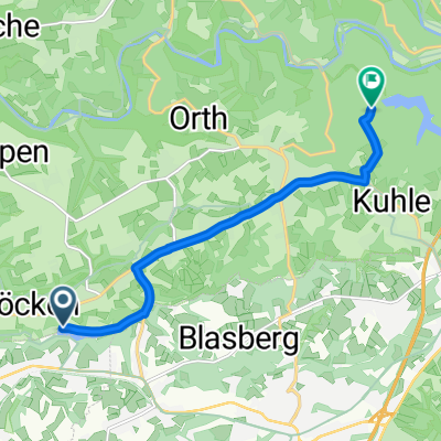
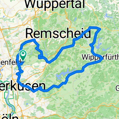
The route crosses three former railway lines and is suitable for road bikes; all gravel sections are avoided. However, there is a small section of cobblestones about 300 m long, which gives a bit of Roubaix feeling! ;-)
You pass through several illuminated tunnels, enjoy magnificent views from the viaducts over Wuppertal, and repeatedly pass stations that have been converted into dining establishments. The railway lines can get crowded on weekends.
- -:--
- Duration
- 84.2 km
- Distance
- 419 m
- Ascent
- 417 m
- Descent
- ---
- Avg. speed
- ---
- Max. altitude
Route photos


Route quality
Waytypes & surfaces along the route
Waytypes
Path
45.5 km
(54 %)
Quiet road
10.1 km
(12 %)
Surfaces
Paved
79.2 km
(94 %)
Asphalt
78.4 km
(93 %)
Paved (undefined)
0.8 km
(1 %)
Undefined
5.1 km
(6 %)
Continue with Bikemap
Use, edit, or download this cycling route
You would like to ride Bahntrassen-Tour or customize it for your own trip? Here is what you can do with this Bikemap route:
Free features
- Save this route as favorite or in collections
- Copy & plan your own version of this route
- Split it into stages to create a multi-day tour
- Sync your route with Garmin or Wahoo
Premium features
Free trial for 3 days, or one-time payment. More about Bikemap Premium.
- Navigate this route on iOS & Android
- Export a GPX / KML file of this route
- Create your custom printout (try it for free)
- Download this route for offline navigation
Discover more Premium features.
Get Bikemap PremiumFrom our community
Other popular routes starting in Leichlingen
 Von Leverkusen bis Solingen
- Distance
- 7.8 km
- Ascent
- 151 m
- Descent
- 94 m
- Location
- Leichlingen, North Rhine-Westphalia, Germany
 Zur Nordhelle
- Distance
- 180.6 km
- Ascent
- 2,445 m
- Descent
- 2,376 m
- Location
- Leichlingen, North Rhine-Westphalia, Germany
 2009.03.22 -Solingen
- Distance
- 35 km
- Ascent
- 653 m
- Descent
- 653 m
- Location
- Leichlingen, North Rhine-Westphalia, Germany
 Rheintour
- Distance
- 31 km
- Ascent
- 119 m
- Descent
- 121 m
- Location
- Leichlingen, North Rhine-Westphalia, Germany
 SG-Solingener Klingenpfad -Light-
- Distance
- 48.8 km
- Ascent
- 453 m
- Descent
- 452 m
- Location
- Leichlingen, North Rhine-Westphalia, Germany
 Bergische Trainings Runde
- Distance
- 106.4 km
- Ascent
- 959 m
- Descent
- 1,015 m
- Location
- Leichlingen, North Rhine-Westphalia, Germany
 Burg und Solingen Stadt Rundweg
- Distance
- 35.7 km
- Ascent
- 328 m
- Descent
- 327 m
- Location
- Leichlingen, North Rhine-Westphalia, Germany
 26. August 09:15 Lennep
- Distance
- 63.4 km
- Ascent
- 460 m
- Descent
- 462 m
- Location
- Leichlingen, North Rhine-Westphalia, Germany
Open it in the app