

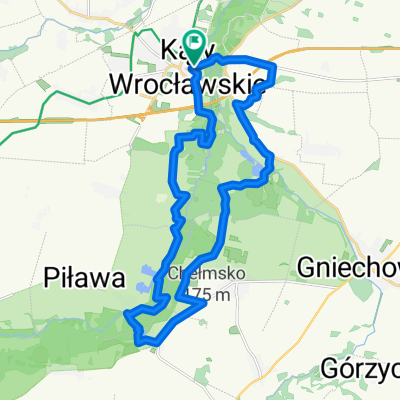
Trasa do Grunwaldzka 17, Kąty Wrocławskie
A cycling route starting in Kąty Wrocławskie, Lower Silesian Voivodeship, Poland.
Overview
About this route
- 1 h 21 min
- Duration
- 19.6 km
- Distance
- 124 m
- Ascent
- 125 m
- Descent
- 14.6 km/h
- Avg. speed
- ---
- Max. altitude

Route quality
Waytypes & surfaces along the route
Waytypes
Track
6.7 km
(34 %)
Road
5.1 km
(26 %)
Surfaces
Paved
9 km
(46 %)
Unpaved
1.8 km
(9 %)
Asphalt
8.4 km
(43 %)
Unpaved (undefined)
0.8 km
(4 %)
Continue with Bikemap
Use, edit, or download this cycling route
You would like to ride Trasa do Grunwaldzka 17, Kąty Wrocławskie or customize it for your own trip? Here is what you can do with this Bikemap route:
Free features
- Save this route as favorite or in collections
- Copy & plan your own version of this route
- Sync your route with Garmin or Wahoo
Premium features
Free trial for 3 days, or one-time payment. More about Bikemap Premium.
- Navigate this route on iOS & Android
- Export a GPX / KML file of this route
- Create your custom printout (try it for free)
- Download this route for offline navigation
Discover more Premium features.
Get Bikemap PremiumFrom our community
Other popular routes starting in Kąty Wrocławskie
 Recovered Route
- Distance
- 4.8 km
- Ascent
- 34 m
- Descent
- 33 m
- Location
- Kąty Wrocławskie, Lower Silesian Voivodeship, Poland
 Dolina Bystrzycy
- Distance
- 47.3 km
- Ascent
- 184 m
- Descent
- 186 m
- Location
- Kąty Wrocławskie, Lower Silesian Voivodeship, Poland
 CX Kąty - Las Ratyński - Kąty
- Distance
- 61.6 km
- Ascent
- 102 m
- Descent
- 108 m
- Location
- Kąty Wrocławskie, Lower Silesian Voivodeship, Poland
 Kąty - Płonica R9
- Distance
- 95.8 km
- Ascent
- 609 m
- Descent
- 498 m
- Location
- Kąty Wrocławskie, Lower Silesian Voivodeship, Poland
 Kąty Wrocławskie Pętla Bielika
- Distance
- 22.9 km
- Ascent
- 123 m
- Descent
- 124 m
- Location
- Kąty Wrocławskie, Lower Silesian Voivodeship, Poland
 Wyjazd dla prawdziwych mężczyzn - dzień 1
- Distance
- 62.3 km
- Ascent
- 881 m
- Descent
- 436 m
- Location
- Kąty Wrocławskie, Lower Silesian Voivodeship, Poland
 Pętla Kąty Wrocławskie - Sobótka - Tąpadła - Pożarzysko - Kąty Wrocławskie
- Distance
- 87.8 km
- Ascent
- 319 m
- Descent
- 320 m
- Location
- Kąty Wrocławskie, Lower Silesian Voivodeship, Poland
 Gruszkowy Ciechan - na pierożki do Sobótki
- Distance
- 41 km
- Ascent
- 314 m
- Descent
- 314 m
- Location
- Kąty Wrocławskie, Lower Silesian Voivodeship, Poland
Open it in the app