

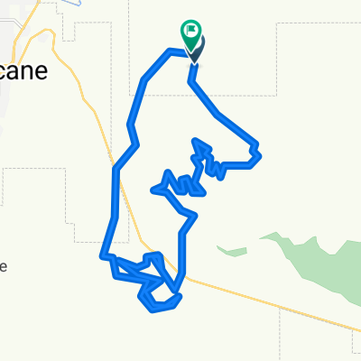
Mountain Bike - Virgin Cross Country
A cycling route starting in LaVerkin, Utah, United States.
Overview
About this route
This race will include sections of the Jem Trail, Cryptobiotic and Hurricane Cliffs.
- -:--
- Duration
- 13.2 km
- Distance
- 169 m
- Ascent
- 168 m
- Descent
- ---
- Avg. speed
- ---
- Max. altitude

Route quality
Waytypes & surfaces along the route
Waytypes
Path
10.7 km
(81 %)
Quiet road
1.7 km
(13 %)
Surfaces
Unpaved
12.5 km
(95 %)
Ground
10.7 km
(81 %)
Gravel
1.7 km
(13 %)
Continue with Bikemap
Use, edit, or download this cycling route
You would like to ride Mountain Bike - Virgin Cross Country or customize it for your own trip? Here is what you can do with this Bikemap route:
Free features
- Save this route as favorite or in collections
- Copy & plan your own version of this route
- Sync your route with Garmin or Wahoo
Premium features
Free trial for 3 days, or one-time payment. More about Bikemap Premium.
- Navigate this route on iOS & Android
- Export a GPX / KML file of this route
- Create your custom printout (try it for free)
- Download this route for offline navigation
Discover more Premium features.
Get Bikemap PremiumFrom our community
Other popular routes starting in LaVerkin
 Kolob terrace bikemap
- Distance
- 30 km
- Ascent
- 1,313 m
- Descent
- 29 m
- Location
- LaVerkin, Utah, United States
 Virgin to Virgin
- Distance
- 35.5 km
- Ascent
- 361 m
- Descent
- 345 m
- Location
- LaVerkin, Utah, United States
 Hurricane (NV avant LV)
- Distance
- 36.8 km
- Ascent
- 509 m
- Descent
- 509 m
- Location
- LaVerkin, Utah, United States
 N Sheep Bridge Rd W, Virgin to N Sheep Bridge Rd W, Virgin
- Distance
- 28.9 km
- Ascent
- 271 m
- Descent
- 274 m
- Location
- LaVerkin, Utah, United States
 Grafton Mesa, UT - St George, UT
- Distance
- 52 km
- Ascent
- 260 m
- Descent
- 531 m
- Location
- LaVerkin, Utah, United States
 Restful route in La Verkin
- Distance
- 8.5 km
- Ascent
- 151 m
- Descent
- 156 m
- Location
- LaVerkin, Utah, United States
 Zion1
Zion1- Distance
- 57.4 km
- Ascent
- 785 m
- Descent
- 431 m
- Location
- LaVerkin, Utah, United States
 Mountain Bike - Virgin Cross Country
- Distance
- 13.2 km
- Ascent
- 169 m
- Descent
- 168 m
- Location
- LaVerkin, Utah, United States
Open it in the app