
Sarre - Fenis nel verde UISP
A cycling route starting in Montan-Angelin-Arensod, Aosta Valley, Italy.
Overview
About this route
Sarre - Fenis in the green UISP
- -:--
- Duration
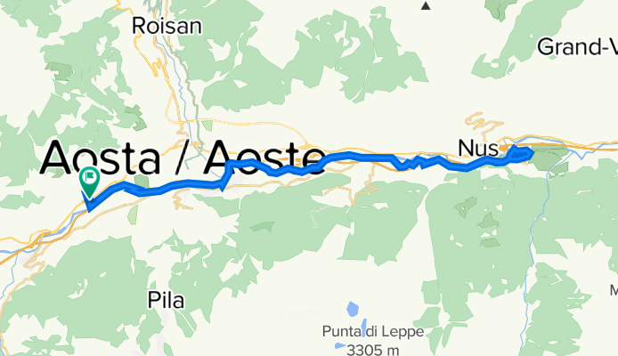
- 41.3 km
- Distance
- 136 m
- Ascent
- 136 m
- Descent
- ---
- Avg. speed
- ---
- Max. altitude

Route quality
Waytypes & surfaces along the route
Waytypes
Cycleway
27.3 km
(66 %)
Road
6.2 km
(15 %)
Surfaces
Paved
28.9 km
(70 %)
Unpaved
1.7 km
(4 %)
Asphalt
28.9 km
(70 %)
Gravel
1.7 km
(4 %)
Undefined
10.7 km
(26 %)
Continue with Bikemap
Use, edit, or download this cycling route
You would like to ride Sarre - Fenis nel verde UISP or customize it for your own trip? Here is what you can do with this Bikemap route:
Free features
- Save this route as favorite or in collections
- Copy & plan your own version of this route
- Sync your route with Garmin or Wahoo
Premium features
Free trial for 3 days, or one-time payment. More about Bikemap Premium.
- Navigate this route on iOS & Android
- Export a GPX / KML file of this route
- Create your custom printout (try it for free)
- Download this route for offline navigation
Discover more Premium features.
Get Bikemap PremiumFrom our community
Other popular routes starting in Montan-Angelin-Arensod
 5. Monte Chaligne
- Distance
- 32.6 km
- Ascent
- 1,901 m
- Descent
- 1,875 m
- Location
- Montan-Angelin-Arensod, Aosta Valley, Italy
 Vda week end traccia Puddu
- Distance
- 32.8 km
- Ascent
- 1,330 m
- Descent
- 1,963 m
- Location
- Montan-Angelin-Arensod, Aosta Valley, Italy
 Uisp Aosta - Sarre Fenis
- Distance
- 41.1 km
- Ascent
- 185 m
- Descent
- 184 m
- Location
- Montan-Angelin-Arensod, Aosta Valley, Italy
 Druges paved and gravel to Lago Layet
- Distance
- 81.5 km
- Ascent
- 1,777 m
- Descent
- 1,777 m
- Location
- Montan-Angelin-Arensod, Aosta Valley, Italy
 (10) Aosta - Oropa
- Distance
- 104.5 km
- Ascent
- 1,269 m
- Descent
- 721 m
- Location
- Montan-Angelin-Arensod, Aosta Valley, Italy
 giro4
giro4- Distance
- 45.1 km
- Ascent
- 2,044 m
- Descent
- 653 m
- Location
- Montan-Angelin-Arensod, Aosta Valley, Italy
 cx
cx- Distance
- 9.5 km
- Ascent
- 40 m
- Descent
- 43 m
- Location
- Montan-Angelin-Arensod, Aosta Valley, Italy
 Giro Charvensod
- Distance
- 18.9 km
- Ascent
- 544 m
- Descent
- 546 m
- Location
- Montan-Angelin-Arensod, Aosta Valley, Italy
Open it in the app