- 34.5 km
- 233 m
- 216 m
- Bamberg, Bavaria, Germany
Über den Jura ins Leinleiter-, Wiesent- und Regnitztal
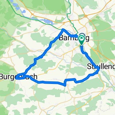
A cycling route starting in Bamberg, Bavaria, Germany.
Overview
About this route
Day tour
We ride along the bike path to Geisfeld, on the road over Zeegendorf to the steep climb (time to push) Teuchatzer Berg, then roll down into Leinleitertal. Its bike path takes us quickly to Wiesenttal. Along the Wiesent, we cycle through Ebermannstadt (stop) to Pretzfeld and Kirchehrenbach at Walberla. On the Auweg and from Reuth along the bike path beside the B 470 we reach Forchheim. Through wide fields, we pedal to Eggolsheim, further over Unterstürmig to Buttenheim (cellar). Along the A 73, we come to Neubert and to Hirschaid (cellar), Strullendorf (cellar) is then not far. The B 505 then guides us back to Bamberg.
- -:--
- Duration
- 73.6 km
- Distance
- 597 m
- Ascent
- 589 m
- Descent
- ---
- Avg. speed
- 545 m
- Max. altitude
created this 18 years ago
Route quality
Waytypes & surfaces along the route
Waytypes
Path
16.9 km
(23 %)
Quiet road
15.5 km
(21 %)
Surfaces
Paved
64 km
(87 %)
Unpaved
5.2 km
(7 %)
Asphalt
64 km
(87 %)
Gravel
5.2 km
(7 %)
Undefined
4.4 km
(6 %)
Route highlights
Points of interest along the route
Point of interest after 44.1 km
Point of interest after 54.1 km
Schwarzer Kreuz-Keller
Point of interest after 57.5 km
Löwenbräu-Keller Buttenheim
Point of interest after 57.5 km
St. Georgen-Keller Buttenheim
Point of interest after 58.1 km
St. Georgen Bräu
Point of interest after 58.1 km
Löwenbräu
Point of interest after 61.1 km
Hirschaider Keller
Point of interest after 65.9 km
Schwanen-Keller Strullendorf
Point of interest after 73.5 km
Parkplatz Graf Stauffenberg Schule Kloster-Langheim-Straße
Continue with Bikemap
Use, edit, or download this cycling route
You would like to ride Über den Jura ins Leinleiter-, Wiesent- und Regnitztal or customize it for your own trip? Here is what you can do with this Bikemap route:
Free features
- Save this route as favorite or in collections
- Copy & plan your own version of this route
- Sync your route with Garmin or Wahoo
Premium features
Free trial for 3 days, or one-time payment. More about Bikemap Premium.
- Navigate this route on iOS & Android
- Export a GPX / KML file of this route
- Create your custom printout (try it for free)
- Download this route for offline navigation
Discover more Premium features.
Get Bikemap PremiumFrom our community
Other popular routes starting in Bamberg
- Bamberg als Start
- 08 Stadt-Land-Fluss Tour 44,7 km
- 43.9 km
- 296 m
- 294 m
- Bamberg, Bavaria, Germany
- Main-Radweg
- 156.4 km
- 822 m
- 884 m
- Bamberg, Bavaria, Germany
- Über den Jura ins Leinleiter-, Wiesent- und Regnitztal
- 73.6 km
- 597 m
- 589 m
- Bamberg, Bavaria, Germany
- Trainigsrunde
- 14.4 km
- 99 m
- 100 m
- Bamberg, Bavaria, Germany
- Bamberg Kurztripp
- 34.8 km
- 71 m
- 73 m
- Bamberg, Bavaria, Germany
- Kletter- und Geniessertour
- 60.5 km
- 655 m
- 649 m
- Bamberg, Bavaria, Germany
- Bamberg Cycling
- 15.7 km
- 82 m
- 43 m
- Bamberg, Bavaria, Germany
Open it in the app


