

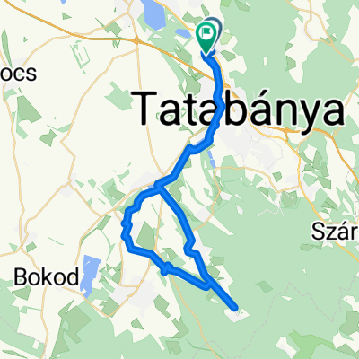
Által-ér
A cycling route starting in Vértesszőlős, Komárom-Esztergom, Hungary.
Overview
About this route
Által-ér
- -:--
- Duration
- 36.7 km
- Distance
- 107 m
- Ascent
- 109 m
- Descent
- ---
- Avg. speed
- ---
- Max. altitude

Route quality
Waytypes & surfaces along the route
Waytypes
Quiet road
15 km
(41 %)
Cycleway
9.2 km
(25 %)
Surfaces
Paved
24.6 km
(67 %)
Unpaved
7 km
(19 %)
Asphalt
23.5 km
(64 %)
Gravel
4 km
(11 %)
Continue with Bikemap
Use, edit, or download this cycling route
You would like to ride Által-ér or customize it for your own trip? Here is what you can do with this Bikemap route:
Free features
- Save this route as favorite or in collections
- Copy & plan your own version of this route
- Sync your route with Garmin or Wahoo
Premium features
Free trial for 3 days, or one-time payment. More about Bikemap Premium.
- Navigate this route on iOS & Android
- Export a GPX / KML file of this route
- Create your custom printout (try it for free)
- Download this route for offline navigation
Discover more Premium features.
Get Bikemap PremiumFrom our community
Other popular routes starting in Vértesszőlős
 Valusek Dezső utca, Vértesszőlős - Camino De Santiago-Szt Jakab Zarándokút, Vértesszőlős
- Distance
- 55.6 km
- Ascent
- 266 m
- Descent
- 269 m
- Location
- Vértesszőlős, Komárom-Esztergom, Hungary
 szőlős-fehérvár
- Distance
- 126 km
- Ascent
- 579 m
- Descent
- 579 m
- Location
- Vértesszőlős, Komárom-Esztergom, Hungary
 tárkány túra
- Distance
- 36.4 km
- Ascent
- 117 m
- Descent
- 155 m
- Location
- Vértesszőlős, Komárom-Esztergom, Hungary
 Hrinya turul
- Distance
- 13.2 km
- Ascent
- 445 m
- Descent
- 274 m
- Location
- Vértesszőlős, Komárom-Esztergom, Hungary
 izebize
- Distance
- 76.4 km
- Ascent
- 362 m
- Descent
- 650 m
- Location
- Vértesszőlős, Komárom-Esztergom, Hungary
 Által-ér
- Distance
- 36.7 km
- Ascent
- 107 m
- Descent
- 109 m
- Location
- Vértesszőlős, Komárom-Esztergom, Hungary
 Múzeum utca, Vértesszőlős - Múzeum utca, Vértesszőlős
- Distance
- 39.4 km
- Ascent
- 147 m
- Descent
- 155 m
- Location
- Vértesszőlős, Komárom-Esztergom, Hungary
 Vértesszőlős-Szomód
- Distance
- 12 km
- Ascent
- 41 m
- Descent
- 68 m
- Location
- Vértesszőlős, Komárom-Esztergom, Hungary
Open it in the app