

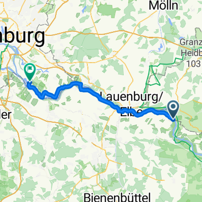
Büchen - Schaalsee - Boizenburg
A cycling route starting in Boizenburg, Mecklenburg-Vorpommern, Germany.
Overview
About this route
Der Schaalsee ist ein Biosphärenreservat in Mecklenburg Vorpommern zwischen Parchim und Hamburg.Dort kann man seltene Tiere und Planzen beobachten.Ausgangspunkt sollte immer das "Pahlhuus"(Infozentrum) sen.
- -:--
- Duration
- 94.6 km
- Distance
- 404 m
- Ascent
- 398 m
- Descent
- ---
- Avg. speed
- ---
- Max. altitude
Route quality
Waytypes & surfaces along the route
Waytypes
Road
41.6 km
(44 %)
Quiet road
18.9 km
(20 %)
Surfaces
Paved
74.7 km
(79 %)
Unpaved
5.7 km
(6 %)
Asphalt
72.8 km
(77 %)
Ground
4.7 km
(5 %)
Route highlights
Points of interest along the route
Point of interest after 25.9 km
Pahlhuus
Continue with Bikemap
Use, edit, or download this cycling route
You would like to ride Büchen - Schaalsee - Boizenburg or customize it for your own trip? Here is what you can do with this Bikemap route:
Free features
- Save this route as favorite or in collections
- Copy & plan your own version of this route
- Split it into stages to create a multi-day tour
- Sync your route with Garmin or Wahoo
Premium features
Free trial for 3 days, or one-time payment. More about Bikemap Premium.
- Navigate this route on iOS & Android
- Export a GPX / KML file of this route
- Create your custom printout (try it for free)
- Download this route for offline navigation
Discover more Premium features.
Get Bikemap PremiumFrom our community
Other popular routes starting in Boizenburg
 Teldauer Grünland Tour (Boizenburg - Teldau - Neu Bleckede - Boizenburg)
- Distance
- 34.5 km
- Ascent
- 59 m
- Descent
- 102 m
- Location
- Boizenburg, Mecklenburg-Vorpommern, Germany
 Boizenburg - Bretziner Heide MTB tour
- Distance
- 20.8 km
- Ascent
- 64 m
- Descent
- 130 m
- Location
- Boizenburg, Mecklenburg-Vorpommern, Germany
 Hochwasser - Winter - Teldau - Sude - Tour
- Distance
- 19.8 km
- Ascent
- 6 m
- Descent
- 73 m
- Location
- Boizenburg, Mecklenburg-Vorpommern, Germany
 Schwartow - Hatzbergtour
- Distance
- 18.1 km
- Ascent
- 77 m
- Descent
- 120 m
- Location
- Boizenburg, Mecklenburg-Vorpommern, Germany
 Bengerstorf: Natur mit Kultur
- Distance
- 56.4 km
- Ascent
- 157 m
- Descent
- 157 m
- Location
- Boizenburg, Mecklenburg-Vorpommern, Germany
 Pfingst Grenztour
- Distance
- 28.9 km
- Ascent
- 29 m
- Descent
- 100 m
- Location
- Boizenburg, Mecklenburg-Vorpommern, Germany
 Mi_Etappe-5 Von Hitzacker (Elbe) bis Drage
- Distance
- 54.8 km
- Ascent
- 31 m
- Descent
- 37 m
- Location
- Boizenburg, Mecklenburg-Vorpommern, Germany
 Grünes Band_Tag 3_Boizenburg - Dömitz
- Distance
- 66.1 km
- Ascent
- 194 m
- Descent
- 185 m
- Location
- Boizenburg, Mecklenburg-Vorpommern, Germany
Open it in the app