

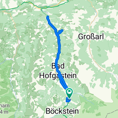
03 Bad Gastein - Tauernschleuse - Millstatt 63km, 100HM
A cycling route starting in Bad Gastein, Salzburg, Austria.
Overview
About this route
- -:--
- Duration
- 63.3 km
- Distance
- 1,833 m
- Ascent
- 2,292 m
- Descent
- ---
- Avg. speed
- ---
- Max. altitude

Route quality
Waytypes & surfaces along the route
Waytypes
Quiet road
17.7 km
(28 %)
Cycleway
17.1 km
(27 %)
Surfaces
Paved
29.1 km
(46 %)
Unpaved
3.2 km
(5 %)
Asphalt
27.2 km
(43 %)
Loose gravel
2.5 km
(4 %)
Continue with Bikemap
Use, edit, or download this cycling route
You would like to ride 03 Bad Gastein - Tauernschleuse - Millstatt 63km, 100HM or customize it for your own trip? Here is what you can do with this Bikemap route:
Free features
- Save this route as favorite or in collections
- Copy & plan your own version of this route
- Sync your route with Garmin or Wahoo
Premium features
Free trial for 3 days, or one-time payment. More about Bikemap Premium.
- Navigate this route on iOS & Android
- Export a GPX / KML file of this route
- Create your custom printout (try it for free)
- Download this route for offline navigation
Discover more Premium features.
Get Bikemap PremiumFrom our community
Other popular routes starting in Bad Gastein
 Badgastein - Dorfgastein
- Distance
- 51.7 km
- Ascent
- 518 m
- Descent
- 518 m
- Location
- Bad Gastein, Salzburg, Austria
 03 Bad Gastein - Spittal an. d. Drau
- Distance
- 63 km
- Ascent
- 922 m
- Descent
- 1,334 m
- Location
- Bad Gastein, Salzburg, Austria
 Bad Gastein - Runde
- Distance
- 54.8 km
- Ascent
- 774 m
- Descent
- 773 m
- Location
- Bad Gastein, Salzburg, Austria
 Ei Rastötzen
- Distance
- 16.5 km
- Ascent
- 658 m
- Descent
- 668 m
- Location
- Bad Gastein, Salzburg, Austria
 Bad Gastein - Villach
- Distance
- 102.3 km
- Ascent
- 873 m
- Descent
- 1,443 m
- Location
- Bad Gastein, Salzburg, Austria
 Großglockner Runde, 2. Tag, 2. Etappe
- Distance
- 38.3 km
- Ascent
- 566 m
- Descent
- 968 m
- Location
- Bad Gastein, Salzburg, Austria
 Karl-Heinrich-Waggerl-Straße 12, Bad Gastein to Kaiser-Franz-Josef-Straße 41, Bad Gastein
- Distance
- 23 km
- Ascent
- 1,149 m
- Descent
- 1,148 m
- Location
- Bad Gastein, Salzburg, Austria
 Stubnerkogel von Bad Gastein
- Distance
- 21.1 km
- Ascent
- 1,501 m
- Descent
- 329 m
- Location
- Bad Gastein, Salzburg, Austria
Open it in the app