SH184: See(n) seh'n geh'n
A cycling route starting in Timmendorfer Strand, Schleswig-Holstein, Germany.
Overview
About this route
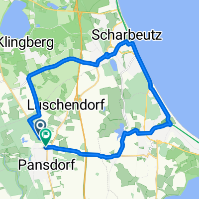
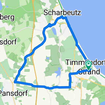
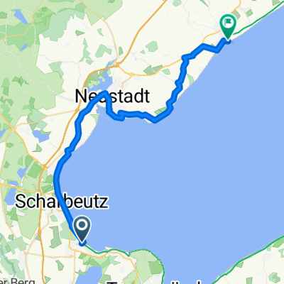
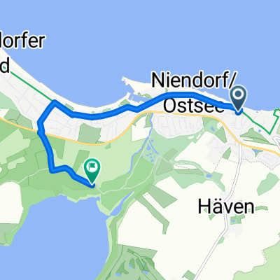
Route of the Scharbeutz Tourism Service. It leads from Timmendorfer Strand through the hilly hinterland of the Baltic Sea coast northwards up to the height of Haffkrug, passing the lakes Oeverdiek, Large and Small Pönitzer See, Taschen See, and Süseler See. From Hof Altona, you roll down to the coast and reach Haffkrug. After a break — the Café Häuschen is recommended with delicious cakes and tarts and a view of the beach promenade / closed on Wednesdays! — you then ride relaxed always along the Baltic Sea beach via Scharbeutz back to the starting point of the tour.
- -:--
- Duration
- 38.2 km
- Distance
- 120 m
- Ascent
- 122 m
- Descent
- ---
- Avg. speed
- 66 m
- Max. altitude
Route photos
Continue with Bikemap
Use, edit, or download this cycling route
You would like to ride SH184: See(n) seh'n geh'n or customize it for your own trip? Here is what you can do with this Bikemap route:
Free features
- Save this route as favorite or in collections
- Copy & plan your own version of this route
- Sync your route with Garmin or Wahoo
Premium features
Free trial for 3 days, or one-time payment. More about Bikemap Premium.
- Navigate this route on iOS & Android
- Export a GPX / KML file of this route
- Create your custom printout (try it for free)
- Download this route for offline navigation
Discover more Premium features.
Get Bikemap PremiumFrom our community
Other popular routes starting in Timmendorfer Strand
Timmendorf-Grömitz2- Distance
- 33 km
- Ascent
- 319 m
- Descent
- 318 m
- Location
- Timmendorfer Strand, Schleswig-Holstein, Germany
Timmendorfer 32- Distance
- 37.3 km
- Ascent
- 125 m
- Descent
- 121 m
- Location
- Timmendorfer Strand, Schleswig-Holstein, Germany
SH301: Süß und Salzig- Distance
- 16.4 km
- Ascent
- 48 m
- Descent
- 47 m
- Location
- Timmendorfer Strand, Schleswig-Holstein, Germany
SH281: Natur satt erfahren- Distance
- 29 km
- Ascent
- 125 m
- Descent
- 126 m
- Location
- Timmendorfer Strand, Schleswig-Holstein, Germany
Dorfstraße nach Dorfstraße- Distance
- 13.5 km
- Ascent
- 81 m
- Descent
- 121 m
- Location
- Timmendorfer Strand, Schleswig-Holstein, Germany
Am Wittinghaaf, Timmendorfer Strand nach Timmendorfer Strand- Distance
- 4.8 km
- Ascent
- 4 m
- Descent
- 13 m
- Location
- Timmendorfer Strand, Schleswig-Holstein, Germany
Pansdorf - Timmendorfer Strand- Distance
- 16.5 km
- Ascent
- 114 m
- Descent
- 112 m
- Location
- Timmendorfer Strand, Schleswig-Holstein, Germany
kleine Runde um das Klärwerk ?- Distance
- 6.3 km
- Ascent
- 4 m
- Descent
- 4 m
- Location
- Timmendorfer Strand, Schleswig-Holstein, Germany
Open it in the app


