

Aggtelekig meg sem állunk
Aggtelek 1.
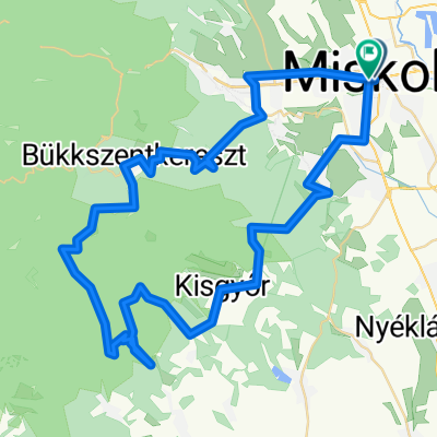
A cycling route starting in Miskolc, Borsod-Abauj Zemplen county, Hungary.
Overview
About this route
- -:--
- Duration
- 18.8 km
- Distance
- 297 m
- Ascent
- 346 m
- Descent
- ---
- Avg. speed
- ---
- Max. altitude

Part of
Aggtelekig meg sem állunk
7 stages
Route quality
Waytypes & surfaces along the route
Waytypes
Track
11.3 km
(60 %)
Quiet road
6.4 km
(34 %)
Surfaces
Paved
6.3 km
(34 %)
Unpaved
11.4 km
(61 %)
Asphalt
6.3 km
(34 %)
Gravel
4.5 km
(24 %)
Route highlights
Points of interest along the route
Point of interest after 0.2 km
Iskola, bicikli raktár
Point of interest after 0.6 km
Laciék
Point of interest after 2.1 km
Emléktábla
Point of interest after 3.3 km
Lófő-tisztás
Point of interest after 14.2 km
Üveghuta múzeum
Point of interest after 14.3 km
Gyertyán-völgyi üveghuta
Point of interest after 14.6 km
Üveghuta temetője
Drinking water after 15.5 km
Point of interest after 15.9 km
Esőbeálló
Continue with Bikemap
Use, edit, or download this cycling route
You would like to ride Aggtelek 1. or customize it for your own trip? Here is what you can do with this Bikemap route:
Free features
- Save this route as favorite or in collections
- Copy & plan your own version of this route
- Sync your route with Garmin or Wahoo
Premium features
Free trial for 3 days, or one-time payment. More about Bikemap Premium.
- Navigate this route on iOS & Android
- Export a GPX / KML file of this route
- Create your custom printout (try it for free)
- Download this route for offline navigation
Discover more Premium features.
Get Bikemap PremiumFrom our community
Other popular routes starting in Miskolc
 Eger-miskolc erdei út
- Distance
- 65.8 km
- Ascent
- 757 m
- Descent
- 718 m
- Location
- Miskolc, Borsod-Abauj Zemplen county, Hungary
 KME - Déli Bükk II. 2016
- Distance
- 70.1 km
- Ascent
- 903 m
- Descent
- 900 m
- Location
- Miskolc, Borsod-Abauj Zemplen county, Hungary
 Miskolc - Lillafüred - Jávorkút - Nagy-mező- Bánkút - Bálvány hegy - Csipkéskút - Ómassa - Miskolc
- Distance
- 82.8 km
- Ascent
- 1,216 m
- Descent
- 1,215 m
- Location
- Miskolc, Borsod-Abauj Zemplen county, Hungary
 Bringával a Bükk csúcsán 2013.
- Distance
- 61.6 km
- Ascent
- 890 m
- Descent
- 889 m
- Location
- Miskolc, Borsod-Abauj Zemplen county, Hungary
 Miskolc-Nyéki tó (István tó)
- Distance
- 45.7 km
- Ascent
- 172 m
- Descent
- 187 m
- Location
- Miskolc, Borsod-Abauj Zemplen county, Hungary
 Könyves-Hámori tó (északi oldalon)
- Distance
- 11.7 km
- Ascent
- 294 m
- Descent
- 142 m
- Location
- Miskolc, Borsod-Abauj Zemplen county, Hungary
 Miskolctapolca-Kisgyőr az év kerékpárútja jelölt
- Distance
- 67.5 km
- Ascent
- 748 m
- Descent
- 750 m
- Location
- Miskolc, Borsod-Abauj Zemplen county, Hungary
 KME - Északi Bükk II. 2016
- Distance
- 55.9 km
- Ascent
- 729 m
- Descent
- 721 m
- Location
- Miskolc, Borsod-Abauj Zemplen county, Hungary
Open it in the app