

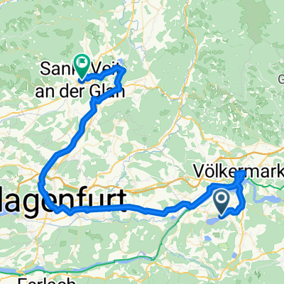
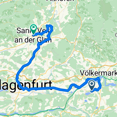
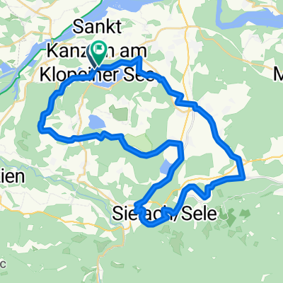
Diexer Panoramatour
A cycling route starting in Eberndorf, Carinthia, Austria.
Overview
About this route
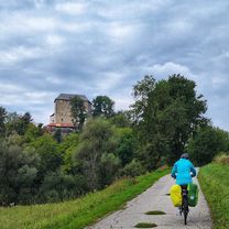
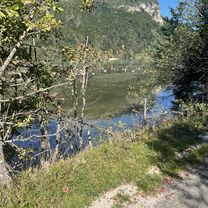
Beautiful road bike tour with stunning views into the Jauntal valley. Up to the climb, we roll about 15 km on side roads through Völkermarkt. The ascent to Diex is 9 km long. The first kilometer is quite steep. From Diex (1,150 m) there is another 150 steep meters uphill. The highest point of the tour is around 1,320 m. Then you ride about 10 km on a high plateau, always up and down, but never dropping below 1,000 m. The alpine landscape up there is beautiful and you repeatedly enjoy dreamlike views into the Jauntal valley and the mountains behind it. The descent from Greutschach to Diex is partly very steep. Through small villages you return to Völkermarkt. On the way back, I recommend a flat roll through Kühnsdorf and Wasserhofen to Klopein.
- -:--
- Duration
- 66.3 km
- Distance
- 1,157 m
- Ascent
- 1,157 m
- Descent
- ---
- Avg. speed
- ---
- Max. altitude

Route quality
Waytypes & surfaces along the route
Waytypes
Quiet road
19.2 km
(29 %)
Road
15.9 km
(24 %)
Surfaces
Paved
33.1 km
(50 %)
Asphalt
29.8 km
(45 %)
Paved (undefined)
3.3 km
(5 %)
Undefined
33.1 km
(50 %)
Continue with Bikemap
Use, edit, or download this cycling route
You would like to ride Diexer Panoramatour or customize it for your own trip? Here is what you can do with this Bikemap route:
Free features
- Save this route as favorite or in collections
- Copy & plan your own version of this route
- Sync your route with Garmin or Wahoo
Premium features
Free trial for 3 days, or one-time payment. More about Bikemap Premium.
- Navigate this route on iOS & Android
- Export a GPX / KML file of this route
- Create your custom printout (try it for free)
- Download this route for offline navigation
Discover more Premium features.
Get Bikemap PremiumFrom our community
Other popular routes starting in Eberndorf
 5.Tag Klopeiner See nach Klagenfurt
- Distance
- 56.1 km
- Ascent
- 207 m
- Descent
- 250 m
- Location
- Eberndorf, Carinthia, Austria
 Westuferstraße, St. Kanzian am Klopeiner See nach Westuferstraße, St. Kanzian am Klopeiner See
- Distance
- 54.9 km
- Ascent
- 454 m
- Descent
- 466 m
- Location
- Eberndorf, Carinthia, Austria
 D5_Klop J - S.Veit in Glain
- Distance
- 74.1 km
- Ascent
- 732 m
- Descent
- 695 m
- Location
- Eberndorf, Carinthia, Austria
 D5_Kärnten Seen-Schleife
- Distance
- 74.2 km
- Ascent
- 713 m
- Descent
- 677 m
- Location
- Eberndorf, Carinthia, Austria
 6-Seen Runde: Für Genussradfahrer und Familien
- Distance
- 39.2 km
- Ascent
- 643 m
- Descent
- 643 m
- Location
- Eberndorf, Carinthia, Austria
 Westuferstraße, St. Kanzian am Klopeiner See nach Am See I, St. Kanzian am Klopeiner See
- Distance
- 20.9 km
- Ascent
- 297 m
- Descent
- 290 m
- Location
- Eberndorf, Carinthia, Austria
 Kopeiner See - 3.day
- Distance
- 46.1 km
- Ascent
- 442 m
- Descent
- 494 m
- Location
- Eberndorf, Carinthia, Austria
 Völkermarkt-Kühnsdorf to Lavamünd
- Distance
- 41.7 km
- Ascent
- 387 m
- Descent
- 484 m
- Location
- Eberndorf, Carinthia, Austria
Open it in the app