

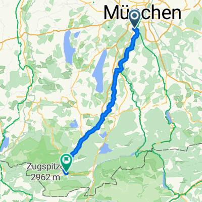
Munich standard
A cycling route starting in Pullach im Isartal, Bavaria, Germany.
Overview
About this route
- -:--
- Duration
- 59.2 km
- Distance
- 317 m
- Ascent
- 317 m
- Descent
- ---
- Avg. speed
- ---
- Max. altitude
Route quality
Waytypes & surfaces along the route
Waytypes
Quiet road
33.7 km
(57 %)
Path
5.9 km
(10 %)
Surfaces
Paved
55.1 km
(93 %)
Unpaved
3.6 km
(6 %)
Asphalt
54.5 km
(92 %)
Ground
1.8 km
(3 %)
Continue with Bikemap
Use, edit, or download this cycling route
You would like to ride Munich standard or customize it for your own trip? Here is what you can do with this Bikemap route:
Free features
- Save this route as favorite or in collections
- Copy & plan your own version of this route
- Sync your route with Garmin or Wahoo
Premium features
Free trial for 3 days, or one-time payment. More about Bikemap Premium.
- Navigate this route on iOS & Android
- Export a GPX / KML file of this route
- Create your custom printout (try it for free)
- Download this route for offline navigation
Discover more Premium features.
Get Bikemap PremiumFrom our community
Other popular routes starting in Pullach im Isartal
 München-Andechs-München
- Distance
- 75.4 km
- Ascent
- 247 m
- Descent
- 244 m
- Location
- Pullach im Isartal, Bavaria, Germany
 Pullach im Isartal - Garmisch-Partenkirchen
- Distance
- 92.6 km
- Ascent
- 646 m
- Descent
- 495 m
- Location
- Pullach im Isartal, Bavaria, Germany
 München-Andechs-Starnberg
- Distance
- 79.7 km
- Ascent
- 630 m
- Descent
- 598 m
- Location
- Pullach im Isartal, Bavaria, Germany
 Feierabendrunde_hh
- Distance
- 30.1 km
- Ascent
- 180 m
- Descent
- 183 m
- Location
- Pullach im Isartal, Bavaria, Germany
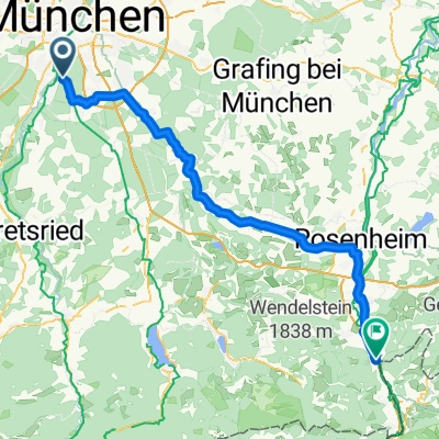 From Rosenheim to Kufstein
- Distance
- 80.8 km
- Ascent
- 351 m
- Descent
- 464 m
- Location
- Pullach im Isartal, Bavaria, Germany
 Obersendling-Otterfing-Aying-Obersendling
- Distance
- 106.7 km
- Ascent
- 604 m
- Descent
- 577 m
- Location
- Pullach im Isartal, Bavaria, Germany
 26.6. München - Ohlstadt
- Distance
- 73.5 km
- Ascent
- 653 m
- Descent
- 513 m
- Location
- Pullach im Isartal, Bavaria, Germany
 T2-Tierpark-Isartrails-Wolfratshausen-Runde
- Distance
- 60.6 km
- Ascent
- 241 m
- Descent
- 237 m
- Location
- Pullach im Isartal, Bavaria, Germany
Open it in the app