

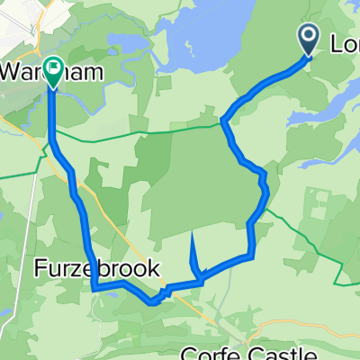
Powolna trasa w Poole
A cycling route starting in Poole, England, United Kingdom.
Overview
About this route
- 58 min
- Duration
- 9.5 km
- Distance
- 0 m
- Ascent
- 3 m
- Descent
- 9.7 km/h
- Avg. speed
- ---
- Max. altitude
Continue with Bikemap
Use, edit, or download this cycling route
You would like to ride Powolna trasa w Poole or customize it for your own trip? Here is what you can do with this Bikemap route:
Free features
- Save this route as favorite or in collections
- Copy & plan your own version of this route
- Sync your route with Garmin or Wahoo
Premium features
Free trial for 3 days, or one-time payment. More about Bikemap Premium.
- Navigate this route on iOS & Android
- Export a GPX / KML file of this route
- Create your custom printout (try it for free)
- Download this route for offline navigation
Discover more Premium features.
Get Bikemap PremiumFrom our community
Other popular routes starting in Poole
 Bourne Greenway Castlemain Trailway
- Distance
- 33.1 km
- Ascent
- 237 m
- Descent
- 228 m
- Location
- Poole, England, United Kingdom
 Purbeck - Corfe Castle
- Distance
- 27.5 km
- Ascent
- 351 m
- Descent
- 344 m
- Location
- Poole, England, United Kingdom
 round the bay
- Distance
- 9.3 km
- Ascent
- 41 m
- Descent
- 42 m
- Location
- Poole, England, United Kingdom
 Route to Braga
- Distance
- 2,064.6 km
- Ascent
- 19,977 m
- Descent
- 19,791 m
- Location
- Poole, England, United Kingdom
 Arne Road, Arne, Wareham to 1 The Quay, Wareham
- Distance
- 13.5 km
- Ascent
- 125 m
- Descent
- 138 m
- Location
- Poole, England, United Kingdom
 Chasing the Sun 2016
- Distance
- 237.6 km
- Ascent
- 1,247 m
- Descent
- 1,248 m
- Location
- Poole, England, United Kingdom
 Porkers 400 Stage 1
- Distance
- 69.2 km
- Ascent
- 484 m
- Descent
- 486 m
- Location
- Poole, England, United Kingdom
 Around Holes Bay
- Distance
- 11.2 km
- Ascent
- 40 m
- Descent
- 39 m
- Location
- Poole, England, United Kingdom
Open it in the app