

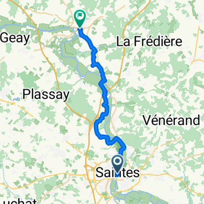
Centre de Saintes - La Baine via route
A cycling route starting in Saintes, Nouvelle-Aquitaine, France.
Overview
About this route
- 35 min
- Duration
- 10 km
- Distance
- 0 m
- Ascent
- 27 m
- Descent
- 17 km/h
- Avg. speed
- ---
- Max. altitude

Route quality
Waytypes & surfaces along the route
Waytypes
Road
7.4 km
(74 %)
Path
1.1 km
(11 %)
Surfaces
Paved
0.2 km
(2 %)
Unpaved
0.5 km
(5 %)
Gravel
0.5 km
(5 %)
Asphalt
0.2 km
(2 %)
Undefined
9.3 km
(93 %)
Continue with Bikemap
Use, edit, or download this cycling route
You would like to ride Centre de Saintes - La Baine via route or customize it for your own trip? Here is what you can do with this Bikemap route:
Free features
- Save this route as favorite or in collections
- Copy & plan your own version of this route
- Sync your route with Garmin or Wahoo
Premium features
Free trial for 3 days, or one-time payment. More about Bikemap Premium.
- Navigate this route on iOS & Android
- Export a GPX / KML file of this route
- Create your custom printout (try it for free)
- Download this route for offline navigation
Discover more Premium features.
Get Bikemap PremiumFrom our community
Other popular routes starting in Saintes
 10. Etappe Saintes nach Royan ca. 39 km 27.06.
- Distance
- 39.3 km
- Ascent
- 133 m
- Descent
- 139 m
- Location
- Saintes, Nouvelle-Aquitaine, France
 Saintes
- Distance
- 12.8 km
- Ascent
- 98 m
- Descent
- 102 m
- Location
- Saintes, Nouvelle-Aquitaine, France
 Centre de Saintes - La Baine via route
- Distance
- 10 km
- Ascent
- 0 m
- Descent
- 27 m
- Location
- Saintes, Nouvelle-Aquitaine, France
 burie
burie- Distance
- 59.2 km
- Ascent
- 266 m
- Descent
- 270 m
- Location
- Saintes, Nouvelle-Aquitaine, France
 Day 05: London to Morocco - Saintes to Le Teste-de-Buch
- Distance
- 191.1 km
- Ascent
- 403 m
- Descent
- 359 m
- Location
- Saintes, Nouvelle-Aquitaine, France
 De 2ter Rue de Chermignac, Saintes à Avenue Président Salvador Allende, Saintes
- Distance
- 14.9 km
- Ascent
- 14 m
- Descent
- 43 m
- Location
- Saintes, Nouvelle-Aquitaine, France
 Saintes - Saint Savinien
- Distance
- 22.2 km
- Ascent
- 110 m
- Descent
- 110 m
- Location
- Saintes, Nouvelle-Aquitaine, France
 Compostela dag 6
- Distance
- 142.5 km
- Ascent
- 283 m
- Descent
- 282 m
- Location
- Saintes, Nouvelle-Aquitaine, France
Open it in the app