

Bunkertour Schlennermarnech mod
A cycling route starting in Bourscheid, District de Diekirch, Luxembourg.
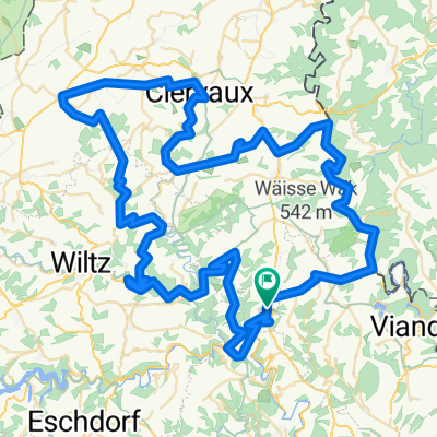
Overview
About this route
Bunkertour Schlennermarnech
- -:--
- Duration
- 17.7 km
- Distance
- 389 m
- Ascent
- 590 m
- Descent
- ---
- Avg. speed
- ---
- Max. altitude

Route highlights
Points of interest along the route

Point of interest after 0 km
Friedbësch
Point of interest after 0.9 km
Bunker Doosbaach

Point of interest after 1 km
Wegweiser

Point of interest after 1.2 km
Léiw Foto

Point of interest after 1.8 km
JOJO

Point of interest after 2.7 km
Point de vue Uewerschleed

Point of interest after 5.5 km
Point de vue Hockslee

Point of interest after 7.6 km
Schéi Baach mat Schiefer

Point of interest after 8.2 km
OH

Point of interest after 8.8 km
Naja

Point of interest after 8.8 km

Point of interest after 8.9 km
--

Point of interest after 9.5 km
Geschwënn doo ?

Point of interest after 12.9 km
Chapelle verpasst
Continue with Bikemap
Use, edit, or download this cycling route
You would like to ride Bunkertour Schlennermarnech mod or customize it for your own trip? Here is what you can do with this Bikemap route:
Free features
- Save this route as favorite or in collections
- Copy & plan your own version of this route
- Sync your route with Garmin or Wahoo
Premium features
Free trial for 3 days, or one-time payment. More about Bikemap Premium.
- Navigate this route on iOS & Android
- Export a GPX / KML file of this route
- Create your custom printout (try it for free)
- Download this route for offline navigation
Discover more Premium features.
Get Bikemap PremiumFrom our community
Other popular routes starting in Bourscheid
 Route to Howald
- Distance
- 61.3 km
- Ascent
- 1,113 m
- Descent
- 1,076 m
- Location
- Bourscheid, District de Diekirch, Luxembourg
 Uewersauer Tour (A) 29/07-30/07 - Vëlosummer 2023
- Distance
- 19.4 km
- Ascent
- 550 m
- Descent
- 451 m
- Location
- Bourscheid, District de Diekirch, Luxembourg
 bourscheid I
- Distance
- 10.5 km
- Ascent
- ---
- Descent
- ---
- Location
- Bourscheid, District de Diekirch, Luxembourg
 Leweck-Stadtbredimus
- Distance
- 86.7 km
- Ascent
- 393 m
- Descent
- 680 m
- Location
- Bourscheid, District de Diekirch, Luxembourg
 Hoscheid Parc Naturel de l'Our 100 km
- Distance
- 99.1 km
- Ascent
- 1,295 m
- Descent
- 1,295 m
- Location
- Bourscheid, District de Diekirch, Luxembourg
 bourscheid II
- Distance
- 14.3 km
- Ascent
- 555 m
- Descent
- 566 m
- Location
- Bourscheid, District de Diekirch, Luxembourg
 XBH - recon part b
- Distance
- 68.9 km
- Ascent
- 2,104 m
- Descent
- 2,020 m
- Location
- Bourscheid, District de Diekirch, Luxembourg
 Lisseneck 4, Parc Housen to Lisseneck 4, Parc Housen
- Distance
- 23.7 km
- Ascent
- 912 m
- Descent
- 1,075 m
- Location
- Bourscheid, District de Diekirch, Luxembourg
Open it in the app