

Samstag-Abend-Lieblingsrunde
A cycling route starting in Schmiedefeld am Rennsteig, Thuringia, Germany.
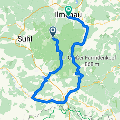
Overview
About this route
Schmiedefeld - Schwarzer Crux - Kreuzwege - Mordfleck - Schmücke - Gr. Beerberg - Rondell - Grenzadler - Axel shelter - Hohe Möst - Karin shelter - Gustav Freytag stone - Kamel shelter - Wachsenrasen - back to Grenzadler - Violet fountain - Ruppberg parking lot - with detours via ski and hiking huts to Knüllfeld - back to Violet fountain - directly to Rondell - original starting route back to Schneekopf parking - Schneekopf - back home
- -:--
- Duration
- 77.6 km
- Distance
- 1,384 m
- Ascent
- 1,391 m
- Descent
- ---
- Avg. speed
- ---
- Max. altitude

Route quality
Waytypes & surfaces along the route
Waytypes
Track
69.8 km
(90 %)
Path
3.9 km
(5 %)
Surfaces
Paved
3.1 km
(4 %)
Unpaved
72.2 km
(93 %)
Gravel
59 km
(76 %)
Ground
10.1 km
(13 %)
Continue with Bikemap
Use, edit, or download this cycling route
You would like to ride Samstag-Abend-Lieblingsrunde or customize it for your own trip? Here is what you can do with this Bikemap route:
Free features
- Save this route as favorite or in collections
- Copy & plan your own version of this route
- Sync your route with Garmin or Wahoo
Premium features
Free trial for 3 days, or one-time payment. More about Bikemap Premium.
- Navigate this route on iOS & Android
- Export a GPX / KML file of this route
- Create your custom printout (try it for free)
- Download this route for offline navigation
Discover more Premium features.
Get Bikemap PremiumFrom our community
Other popular routes starting in Schmiedefeld am Rennsteig
 Knüllfeld und zurück
- Distance
- 55.3 km
- Ascent
- 1,073 m
- Descent
- 1,070 m
- Location
- Schmiedefeld am Rennsteig, Thuringia, Germany
 Ilmtal-Radweg
- Distance
- 0.3 km
- Ascent
- 0 m
- Descent
- 12 m
- Location
- Schmiedefeld am Rennsteig, Thuringia, Germany
 2018-06-09: Bhf Rennsteig - Werra-Quelle
- Distance
- 96.3 km
- Ascent
- 802 m
- Descent
- 1,075 m
- Location
- Schmiedefeld am Rennsteig, Thuringia, Germany
 Adlersberg (Rückweg: Schmiedefeld-Stützerbach-Gehlberg-Großer Beerberg)
- Distance
- 54.5 km
- Ascent
- 699 m
- Descent
- 1,135 m
- Location
- Schmiedefeld am Rennsteig, Thuringia, Germany
 Ilmtal-Radweg
- Distance
- 119.8 km
- Ascent
- 116 m
- Descent
- 747 m
- Location
- Schmiedefeld am Rennsteig, Thuringia, Germany
 Thüringer Wald Vessertal Rund um Schmiedefeld am rennsteig
- Distance
- 37.7 km
- Ascent
- 626 m
- Descent
- 626 m
- Location
- Schmiedefeld am Rennsteig, Thuringia, Germany
 Crux-Wegscheide-Stutenhaus
- Distance
- 14 km
- Ascent
- 275 m
- Descent
- 277 m
- Location
- Schmiedefeld am Rennsteig, Thuringia, Germany
 RSSL_2012_6
- Distance
- 19.6 km
- Ascent
- 402 m
- Descent
- 321 m
- Location
- Schmiedefeld am Rennsteig, Thuringia, Germany
Open it in the app