

VTT HOHNACK LABAROCHE GALTZ
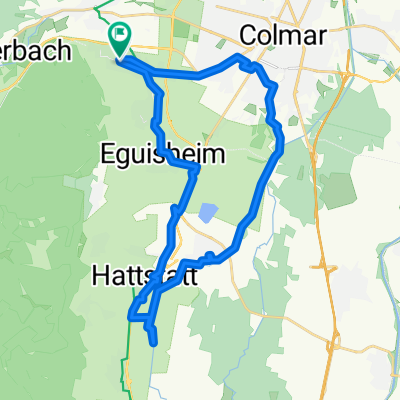
A cycling route starting in Wintzenheim, Grand Est, France.
Overview
About this route
Gentle ascent followed by a descent towards the golf course before tough climbs towards the 3 Épis and then the Galtz....
- -:--
- Duration
- 48 km
- Distance
- 1,470 m
- Ascent
- 1,470 m
- Descent
- ---
- Avg. speed
- ---
- Max. altitude

Route quality
Waytypes & surfaces along the route
Waytypes
Track
25.9 km
(54 %)
Quiet road
10.6 km
(22 %)
Surfaces
Paved
8.2 km
(17 %)
Unpaved
30.7 km
(64 %)
Ground
19.7 km
(41 %)
Gravel
8.2 km
(17 %)
Continue with Bikemap
Use, edit, or download this cycling route
You would like to ride VTT HOHNACK LABAROCHE GALTZ or customize it for your own trip? Here is what you can do with this Bikemap route:
Free features
- Save this route as favorite or in collections
- Copy & plan your own version of this route
- Sync your route with Garmin or Wahoo
Premium features
Free trial for 3 days, or one-time payment. More about Bikemap Premium.
- Navigate this route on iOS & Android
- Export a GPX / KML file of this route
- Create your custom printout (try it for free)
- Download this route for offline navigation
Discover more Premium features.
Get Bikemap PremiumFrom our community
Other popular routes starting in Wintzenheim
 Petite boucle sud Wintzenheim 20km
- Distance
- 29.6 km
- Ascent
- 107 m
- Descent
- 107 m
- Location
- Wintzenheim, Grand Est, France
 Grand Ballon
- Distance
- 115.2 km
- Ascent
- 2,513 m
- Descent
- 2,070 m
- Location
- Wintzenheim, Grand Est, France
 110km Grand Ballon
- Distance
- 110.1 km
- Ascent
- 1,512 m
- Descent
- 1,515 m
- Location
- Wintzenheim, Grand Est, France
 Route du Vignoble
- Distance
- 154.5 km
- Ascent
- 193 m
- Descent
- 256 m
- Location
- Wintzenheim, Grand Est, France
 De Rue d'Eisenstadt 3, Colmar à Rue d'Eisenstadt 2, Colmar
- Distance
- 28.6 km
- Ascent
- 169 m
- Descent
- 222 m
- Location
- Wintzenheim, Grand Est, France
 Vogesen spezial
- Distance
- 135 km
- Ascent
- 2,246 m
- Descent
- 2,246 m
- Location
- Wintzenheim, Grand Est, France
 VTT HOHNACK LABAROCHE GALTZ
- Distance
- 48 km
- Ascent
- 1,470 m
- Descent
- 1,470 m
- Location
- Wintzenheim, Grand Est, France
 Croix de Ribeau - Schantzel - HK
- Distance
- 85 km
- Ascent
- 1,541 m
- Descent
- 1,540 m
- Location
- Wintzenheim, Grand Est, France
Open it in the app