

¿?⁄›? nach ¿?⁄›?
A cycling route starting in Isenbüttel, Lower Saxony, Germany.
Overview
About this route
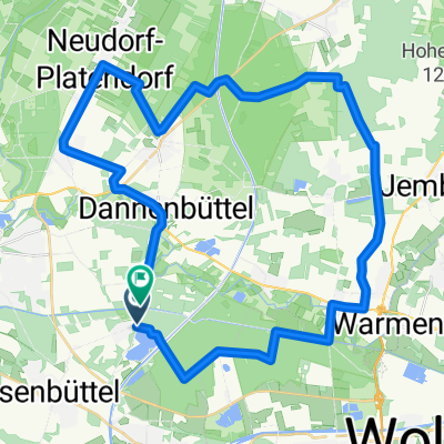
- 2 h 10 min
- Duration
- 20.8 km
- Distance
- 99 m
- Ascent
- 94 m
- Descent
- 9.6 km/h
- Avg. speed
- ---
- Max. altitude
Continue with Bikemap
Use, edit, or download this cycling route
You would like to ride ¿?⁄›? nach ¿?⁄›? or customize it for your own trip? Here is what you can do with this Bikemap route:
Free features
- Save this route as favorite or in collections
- Copy & plan your own version of this route
- Sync your route with Garmin or Wahoo
Premium features
Free trial for 3 days, or one-time payment. More about Bikemap Premium.
- Navigate this route on iOS & Android
- Export a GPX / KML file of this route
- Create your custom printout (try it for free)
- Download this route for offline navigation
Discover more Premium features.
Get Bikemap PremiumFrom our community
Other popular routes starting in Isenbüttel
 Weyhausen, Bokensdorf, Westerbeck, E-Bike
- Distance
- 40.6 km
- Ascent
- 83 m
- Descent
- 81 m
- Location
- Isenbüttel, Lower Saxony, Germany
 Wehyhausen, Brechtorf, Rühen, Kanal zurück
- Distance
- 55.7 km
- Ascent
- 63 m
- Descent
- 63 m
- Location
- Isenbüttel, Lower Saxony, Germany
 Elmtour
- Distance
- 95.5 km
- Ascent
- 433 m
- Descent
- 419 m
- Location
- Isenbüttel, Lower Saxony, Germany
 Tankumsee, Weyhausen, Allersee, am Kanal zurück
- Distance
- 38.9 km
- Ascent
- 37 m
- Descent
- 34 m
- Location
- Isenbüttel, Lower Saxony, Germany
 125'er Celle
- Distance
- 123.8 km
- Ascent
- 76 m
- Descent
- 76 m
- Location
- Isenbüttel, Lower Saxony, Germany
 Sonntagstour2
- Distance
- 33.9 km
- Ascent
- 71 m
- Descent
- 66 m
- Location
- Isenbüttel, Lower Saxony, Germany
 Elbeseiten-Kanal
- Distance
- 30.7 km
- Ascent
- 51 m
- Descent
- 53 m
- Location
- Isenbüttel, Lower Saxony, Germany
 Wasser- und Waldtour
- Distance
- 55 km
- Ascent
- 187 m
- Descent
- 177 m
- Location
- Isenbüttel, Lower Saxony, Germany
Open it in the app