

Trasa do ¿èQ??
A cycling route starting in Krynica-Zdrój, Lesser Poland Voivodeship, Poland.
Overview
About this route
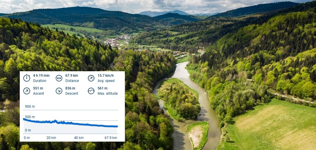
- 1 h 34 min
- Duration
- 17.9 km
- Distance
- 1,157 m
- Ascent
- 1,079 m
- Descent
- 11.5 km/h
- Avg. speed
- ---
- Max. altitude
Continue with Bikemap
Use, edit, or download this cycling route
You would like to ride Trasa do ¿èQ?? or customize it for your own trip? Here is what you can do with this Bikemap route:
Free features
- Save this route as favorite or in collections
- Copy & plan your own version of this route
- Sync your route with Garmin or Wahoo
Premium features
Free trial for 3 days, or one-time payment. More about Bikemap Premium.
- Navigate this route on iOS & Android
- Export a GPX / KML file of this route
- Create your custom printout (try it for free)
- Download this route for offline navigation
Discover more Premium features.
Get Bikemap PremiumFrom our community
Other popular routes starting in Krynica-Zdrój
 Czarny Potok_Jaworzyna Krynicka_Runek_Hala Łabowska_Łomnica Zdrój_Wierchomla WIelka_Muszyna_Krynica_Czarny Potok
- Distance
- 64.3 km
- Ascent
- 955 m
- Descent
- 959 m
- Location
- Krynica-Zdrój, Lesser Poland Voivodeship, Poland
 Krynica Zdrój do Nowego Sącza
- Distance
- 71.3 km
- Ascent
- 621 m
- Descent
- 901 m
- Location
- Krynica-Zdrój, Lesser Poland Voivodeship, Poland
 Śladami maratonów MTB *** Krynica MTB giga (cut)
- Distance
- 27.8 km
- Ascent
- 841 m
- Descent
- 841 m
- Location
- Krynica-Zdrój, Lesser Poland Voivodeship, Poland
 Majka days 2017 - 75km
- Distance
- 75.8 km
- Ascent
- 1,244 m
- Descent
- 1,070 m
- Location
- Krynica-Zdrój, Lesser Poland Voivodeship, Poland
 2025majAniad3
- Distance
- 91.8 km
- Ascent
- 1,149 m
- Descent
- 1,708 m
- Location
- Krynica-Zdrój, Lesser Poland Voivodeship, Poland
 Krynica - Muszyna - Krynica - 14 sierpnia, 10:25
- Distance
- 29 km
- Ascent
- 191 m
- Descent
- 221 m
- Location
- Krynica-Zdrój, Lesser Poland Voivodeship, Poland
 Majka Days - dystans długi
- Distance
- 74.5 km
- Ascent
- 954 m
- Descent
- 768 m
- Location
- Krynica-Zdrój, Lesser Poland Voivodeship, Poland
 Z Beskidu Sądeckiego w Beskid Niski z przyczepką
- Distance
- 31.4 km
- Ascent
- 679 m
- Descent
- 679 m
- Location
- Krynica-Zdrój, Lesser Poland Voivodeship, Poland
Open it in the app