
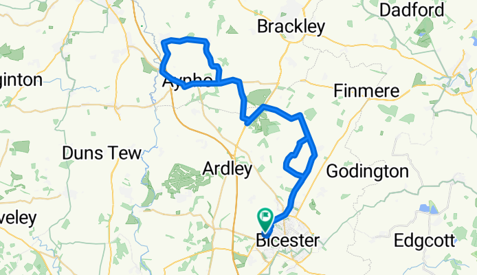
Kings Sutton loop.
A cycling route starting in Bicester, England, United Kingdom.
Overview
About this route
- 2 h 19 min
- Duration
- 51.8 km
- Distance
- 360 m
- Ascent
- 358 m
- Descent
- 22.3 km/h
- Avg. speed
- ---
- Max. altitude

Route quality
Waytypes & surfaces along the route
Waytypes
Quiet road
37.3 km
(72 %)
Busy road
11.5 km
(22 %)
Surfaces
Paved
14.9 km
(29 %)
Asphalt
14.8 km
(29 %)
Paving stones
0.1 km
(<1 %)
Undefined
36.9 km
(71 %)
Continue with Bikemap
Use, edit, or download this cycling route
You would like to ride Kings Sutton loop. or customize it for your own trip? Here is what you can do with this Bikemap route:
Free features
- Save this route as favorite or in collections
- Copy & plan your own version of this route
- Sync your route with Garmin or Wahoo
Premium features
Free trial for 3 days, or one-time payment. More about Bikemap Premium.
- Navigate this route on iOS & Android
- Export a GPX / KML file of this route
- Create your custom printout (try it for free)
- Download this route for offline navigation
Discover more Premium features.
Get Bikemap PremiumFrom our community
Other popular routes starting in Bicester
 Bicester Circle
- Distance
- 38.5 km
- Ascent
- 112 m
- Descent
- 111 m
- Location
- Bicester, England, United Kingdom
 small circle
- Distance
- 20.5 km
- Ascent
- 370 m
- Descent
- 382 m
- Location
- Bicester, England, United Kingdom
 Bure Park - Stoke Wood - Ardely - BP
- Distance
- 21.2 km
- Ascent
- 89 m
- Descent
- 90 m
- Location
- Bicester, England, United Kingdom
 Bicester - Islip - Arncott - Bicester
- Distance
- 44 km
- Ascent
- 179 m
- Descent
- 180 m
- Location
- Bicester, England, United Kingdom
 Bicester Isolation Route 3
- Distance
- 80.4 km
- Ascent
- 566 m
- Descent
- 568 m
- Location
- Bicester, England, United Kingdom
 Bicester to Winslow and back
- Distance
- 47.1 km
- Ascent
- 219 m
- Descent
- 219 m
- Location
- Bicester, England, United Kingdom
 Buckingham Road to The Green 25, Upper Heyford
- Distance
- 11.3 km
- Ascent
- 71 m
- Descent
- 55 m
- Location
- Bicester, England, United Kingdom
 5k Eco Ride
- Distance
- 5.7 km
- Ascent
- 9 m
- Descent
- 8 m
- Location
- Bicester, England, United Kingdom
Open it in the app