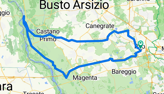
Itinerari per sito
Tornavento tra Villoresi e Naviglio
A cycling route starting in Rho, Lombardy, Italy.
Overview
About this route
- -:--
- Duration
- 77.2 km
- Distance
- 163 m
- Ascent
- 166 m
- Descent
- ---
- Avg. speed
- ---
- Max. altitude
Part of
Itinerari per sito
11 stages
Route quality
Waytypes & surfaces along the route
Waytypes
Cycleway
46.3 km
(60 %)
Quiet road
13.9 km
(18 %)
Surfaces
Paved
61.8 km
(80 %)
Unpaved
7.7 km
(10 %)
Asphalt
61 km
(79 %)
Unpaved (undefined)
3.9 km
(5 %)
Continue with Bikemap
Use, edit, or download this cycling route
You would like to ride Tornavento tra Villoresi e Naviglio or customize it for your own trip? Here is what you can do with this Bikemap route:
Free features
- Save this route as favorite or in collections
- Copy & plan your own version of this route
- Sync your route with Garmin or Wahoo
Premium features
Free trial for 3 days, or one-time payment. More about Bikemap Premium.
- Navigate this route on iOS & Android
- Export a GPX / KML file of this route
- Create your custom printout (try it for free)
- Download this route for offline navigation
Discover more Premium features.
Get Bikemap PremiumFrom our community
Other popular routes starting in Rho
- Giro Villoresi Naviglio Grande
- Distance
- 83.2 km
- Ascent
- 0 m
- Descent
- 160 m
- Location
- Rho, Lombardy, Italy
- Itinerario archeologico Rho variante
- Distance
- 14.6 km
- Ascent
- 47 m
- Descent
- 49 m
- Location
- Rho, Lombardy, Italy
- progetto finale bikemap
- Distance
- 19.9 km
- Ascent
- 49 m
- Descent
- 50 m
- Location
- Rho, Lombardy, Italy
- itinerario storico-artistico rho
- Distance
- 7.9 km
- Ascent
- 15 m
- Descent
- 15 m
- Location
- Rho, Lombardy, Italy
- Rho - Diga del Panperduto
- Distance
- 45.8 km
- Ascent
- 118 m
- Descent
- 84 m
- Location
- Rho, Lombardy, Italy
- Itinerario archeologico Rho
- Distance
- 12.4 km
- Ascent
- 25 m
- Descent
- 21 m
- Location
- Rho, Lombardy, Italy
- Tour murales Rho variante
- Distance
- 7.7 km
- Ascent
- 28 m
- Descent
- 28 m
- Location
- Rho, Lombardy, Italy
- Percorso Naturalistico variante
- Distance
- 22 km
- Ascent
- 53 m
- Descent
- 52 m
- Location
- Rho, Lombardy, Italy
Open it in the app