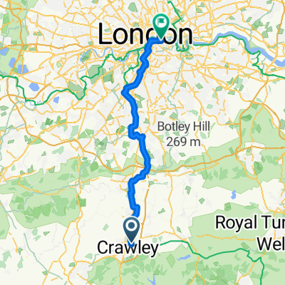
Norwood Hill
A cycling route starting in Crawley, England, United Kingdom.
Overview
About this route
- 1 h 43 min
- Duration
- 32.3 km
- Distance
- 59 m
- Ascent
- 61 m
- Descent
- 18.8 km/h
- Avg. speed
- ---
- Avg. speed
Route quality
Waytypes & surfaces along the route
Waytypes
Road
20.3 km
(63 %)
Quiet road
5.9 km
(18 %)
Surfaces
Paved
14.7 km
(46 %)
Asphalt
14.6 km
(45 %)
Paved (undefined)
0.1 km
(<1 %)
Undefined
17.6 km
(54 %)
Continue with Bikemap
Use, edit, or download this cycling route
You would like to ride Norwood Hill or customize it for your own trip? Here is what you can do with this Bikemap route:
Free features
- Save this route as favorite or in collections
- Copy & plan your own version of this route
- Sync your route with Garmin or Wahoo
Premium features
Free trial for 3 days, or one-time payment. More about Bikemap Premium.
- Navigate this route on iOS & Android
- Export a GPX / KML file of this route
- Create your custom printout (try it for free)
- Download this route for offline navigation
Discover more Premium features.
Get Bikemap PremiumFrom our community
Other popular routes starting in Crawley
- Kilnmead 68 to Garratt Lane 5
- Distance
- 64.1 km
- Ascent
- 362 m
- Descent
- 377 m
- Location
- Crawley, England, United Kingdom
- Crawley loop
- Distance
- 111.3 km
- Ascent
- 444 m
- Descent
- 444 m
- Location
- Crawley, England, United Kingdom
- Crawley Station-Crawley FC Circular
- Distance
- 6.9 km
- Ascent
- 68 m
- Descent
- 68 m
- Location
- Crawley, England, United Kingdom
- Ruta England Larga
- Distance
- 263.2 km
- Ascent
- 690 m
- Descent
- 769 m
- Location
- Crawley, England, United Kingdom
- Crawley to East Grinstead
- Distance
- 13.5 km
- Ascent
- 122 m
- Descent
- 70 m
- Location
- Crawley, England, United Kingdom
- Newchapel
- Distance
- 27.5 km
- Ascent
- 73 m
- Descent
- 75 m
- Location
- Crawley, England, United Kingdom
- To Strawberry Fields
- Distance
- 46.8 km
- Ascent
- 308 m
- Descent
- 306 m
- Location
- Crawley, England, United Kingdom
- Tanhouse via Capel
- Distance
- 43.8 km
- Ascent
- 213 m
- Descent
- 214 m
- Location
- Crawley, England, United Kingdom
Open it in the app