

3 pogwizodwy wersja poprawiona przez ojca
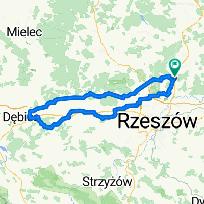
A cycling route starting in Wysoka Głogowska, Subcarpathian Voivodeship, Poland.
Overview
About this route
3rd revised version improved by the father
- -:--
- Duration
- 80.6 km
- Distance
- 219 m
- Ascent
- 217 m
- Descent
- ---
- Avg. speed
- ---
- Max. altitude

Route quality
Waytypes & surfaces along the route
Waytypes
Road
29.8 km
(37 %)
Quiet road
28.2 km
(35 %)
Surfaces
Paved
64.5 km
(80 %)
Unpaved
0.8 km
(1 %)
Asphalt
64.5 km
(80 %)
Gravel
0.8 km
(1 %)
Undefined
15.3 km
(19 %)
Continue with Bikemap
Use, edit, or download this cycling route
You would like to ride 3 pogwizodwy wersja poprawiona przez ojca or customize it for your own trip? Here is what you can do with this Bikemap route:
Free features
- Save this route as favorite or in collections
- Copy & plan your own version of this route
- Split it into stages to create a multi-day tour
- Sync your route with Garmin or Wahoo
Premium features
Free trial for 3 days, or one-time payment. More about Bikemap Premium.
- Navigate this route on iOS & Android
- Export a GPX / KML file of this route
- Create your custom printout (try it for free)
- Download this route for offline navigation
Discover more Premium features.
Get Bikemap PremiumFrom our community
Other popular routes starting in Wysoka Głogowska
 3 pogwizodwy wersja poprawiona przez ojca
- Distance
- 80.6 km
- Ascent
- 219 m
- Descent
- 217 m
- Location
- Wysoka Głogowska, Subcarpathian Voivodeship, Poland
 terenowa 50
- Distance
- 49 km
- Ascent
- 357 m
- Descent
- 361 m
- Location
- Wysoka Głogowska, Subcarpathian Voivodeship, Poland
 pacanow
- Distance
- 198.7 km
- Ascent
- 326 m
- Descent
- 324 m
- Location
- Wysoka Głogowska, Subcarpathian Voivodeship, Poland
 dębica i druga stobierna 122km
- Distance
- 125 km
- Ascent
- 468 m
- Descent
- 465 m
- Location
- Wysoka Głogowska, Subcarpathian Voivodeship, Poland
 dębica i druga stobierna WERSJA GOTOWA 121km ZYDSON EDITION
- Distance
- 123.9 km
- Ascent
- 357 m
- Descent
- 358 m
- Location
- Wysoka Głogowska, Subcarpathian Voivodeship, Poland
 całość kozak trasy v1
- Distance
- 150.9 km
- Ascent
- 455 m
- Descent
- 456 m
- Location
- Wysoka Głogowska, Subcarpathian Voivodeship, Poland
 kozak pentla 2 huciska i lowisko pogorzalka
- Distance
- 101 km
- Ascent
- 249 m
- Descent
- 250 m
- Location
- Wysoka Głogowska, Subcarpathian Voivodeship, Poland
 150-sandomierz
- Distance
- 78.1 km
- Ascent
- 164 m
- Descent
- 234 m
- Location
- Wysoka Głogowska, Subcarpathian Voivodeship, Poland
Open it in the app