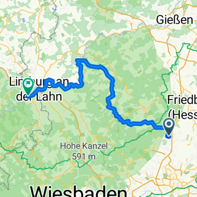
2010-07-23-Stadtschlampe-Stierstadt-Nidda
A cycling route starting in Friedrichsdorf, Hesse, Germany.
Overview
About this route
Garmin:
Total Ascent 271 Hm
Moving Time 1:42 h:min
Odometer 37,39 km
- -:--
- Duration
- 37.1 km
- Distance
- 138 m
- Ascent
- 135 m
- Descent
- ---
- Avg. speed
- ---
- Max. altitude
Route quality
Waytypes & surfaces along the route
Waytypes
Track
10.2 km
(28 %)
Quiet road
9.1 km
(25 %)
Surfaces
Paved
31.6 km
(85 %)
Unpaved
2.5 km
(7 %)
Asphalt
28.5 km
(77 %)
Gravel
2.3 km
(6 %)
Continue with Bikemap
Use, edit, or download this cycling route
You would like to ride 2010-07-23-Stadtschlampe-Stierstadt-Nidda or customize it for your own trip? Here is what you can do with this Bikemap route:
Free features
- Save this route as favorite or in collections
- Copy & plan your own version of this route
- Sync your route with Garmin or Wahoo
Premium features
Free trial for 3 days, or one-time payment. More about Bikemap Premium.
- Navigate this route on iOS & Android
- Export a GPX / KML file of this route
- Create your custom printout (try it for free)
- Download this route for offline navigation
Discover more Premium features.
Get Bikemap PremiumFrom our community
Other popular routes starting in Friedrichsdorf
- Cyclocross Nidda Taunus 28.9.2011
- Distance
- 46.9 km
- Ascent
- 408 m
- Descent
- 408 m
- Location
- Friedrichsdorf, Hesse, Germany
- Rund um den Feldberg
- Distance
- 55.9 km
- Ascent
- 978 m
- Descent
- 980 m
- Location
- Friedrichsdorf, Hesse, Germany
- 2010-07-23-Stadtschlampe-Stierstadt-Nidda
- Distance
- 37.1 km
- Ascent
- 138 m
- Descent
- 135 m
- Location
- Friedrichsdorf, Hesse, Germany
- Fdorf - Steinbruch - Winterstein - Wehrheim - Fdorf
- Distance
- 33.2 km
- Ascent
- 472 m
- Descent
- 472 m
- Location
- Friedrichsdorf, Hesse, Germany
- Wetterau 2
- Distance
- 80 km
- Ascent
- 395 m
- Descent
- 395 m
- Location
- Friedrichsdorf, Hesse, Germany
- RH-HG-Salburg-Obernhain-Wehrheim-RH
- Distance
- 31 km
- Ascent
- 341 m
- Descent
- 347 m
- Location
- Friedrichsdorf, Hesse, Germany
- 2010-07-21-MTB-Taunustour
- Distance
- 94.7 km
- Ascent
- 1,682 m
- Descent
- 1,682 m
- Location
- Friedrichsdorf, Hesse, Germany
- Gemütliche Samstagstour
- Distance
- 47.8 km
- Ascent
- 832 m
- Descent
- 832 m
- Location
- Friedrichsdorf, Hesse, Germany
Open it in the app