

De HôF<? à HôF<?
A cycling route starting in Paudex, Canton of Vaud, Switzerland.
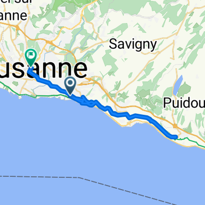
Overview
About this route
- 34 min
- Duration
- 11.2 km
- Distance
- 91 m
- Ascent
- 88 m
- Descent
- 19.8 km/h
- Avg. speed
- ---
- Max. altitude
Route quality
Waytypes & surfaces along the route
Waytypes
Quiet road
2.5 km
(22 %)
Pedestrian area
1.2 km
(11 %)
Surfaces
Paved
10 km
(90 %)
Unpaved
0.2 km
(2 %)
Asphalt
9.9 km
(89 %)
Loose gravel
0.2 km
(2 %)
Continue with Bikemap
Use, edit, or download this cycling route
You would like to ride De HôF<? à HôF<? or customize it for your own trip? Here is what you can do with this Bikemap route:
Free features
- Save this route as favorite or in collections
- Copy & plan your own version of this route
- Sync your route with Garmin or Wahoo
Premium features
Free trial for 3 days, or one-time payment. More about Bikemap Premium.
- Navigate this route on iOS & Android
- Export a GPX / KML file of this route
- Create your custom printout (try it for free)
- Download this route for offline navigation
Discover more Premium features.
Get Bikemap PremiumFrom our community
Other popular routes starting in Paudex
 Route du Simplon 14, Paudex to Avenue de Tivoli 25, Lausanne
- Distance
- 48 km
- Ascent
- 1,066 m
- Descent
- 1,459 m
- Location
- Paudex, Canton of Vaud, Switzerland
 Pully - Mont Pèlerin - Puidoux - Chemin de Montchervet (env.15%)
- Distance
- 46.2 km
- Ascent
- 989 m
- Descent
- 981 m
- Location
- Paudex, Canton of Vaud, Switzerland
 De 9 25, Paudex à Rue Saint-Martin 36, Lausanne
- Distance
- 24.2 km
- Ascent
- 580 m
- Descent
- 437 m
- Location
- Paudex, Canton of Vaud, Switzerland
 Parcours 2021
- Distance
- 213.9 km
- Ascent
- 2,409 m
- Descent
- 2,408 m
- Location
- Paudex, Canton of Vaud, Switzerland
 14.03.10
- Distance
- 50.6 km
- Ascent
- 929 m
- Descent
- 646 m
- Location
- Paudex, Canton of Vaud, Switzerland
 Lausanne-Gruyeres
- Distance
- 53 km
- Ascent
- 787 m
- Descent
- 417 m
- Location
- Paudex, Canton of Vaud, Switzerland
 Mongibel-Tess
- Distance
- 17.8 km
- Ascent
- 194 m
- Descent
- 180 m
- Location
- Paudex, Canton of Vaud, Switzerland
 Chemin de la Grangette 3, Paudex to Chemin de la Grangette 3, Paudex
- Distance
- 110.1 km
- Ascent
- 1,276 m
- Descent
- 1,276 m
- Location
- Paudex, Canton of Vaud, Switzerland
Open it in the app