

Aggtelekig meg sem állunk
Aggtelek 5.
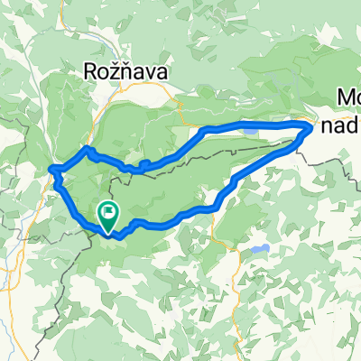
A cycling route starting in Rudabánya, Borsod-Abauj Zemplen county, Hungary.
Overview
About this route
- -:--
- Duration
- 23.7 km
- Distance
- 139 m
- Ascent
- 262 m
- Descent
- ---
- Avg. speed
- ---
- Max. altitude

Part of
Aggtelekig meg sem állunk
7 stages
Route quality
Waytypes & surfaces along the route
Waytypes
Road
4.7 km
(20 %)
Quiet road
1.4 km
(6 %)
Surfaces
Paved
8.3 km
(35 %)
Unpaved
1.2 km
(5 %)
Asphalt
8.3 km
(35 %)
Ground
0.9 km
(4 %)
Route highlights
Points of interest along the route
Point of interest after 0 km
Indulás időben, 9:00 körül, hogy a jósvafői barlanghoz időben érjünk oda! PULÓVER!!!!!!!!
Point of interest after 6.1 km
Barlang bemutató, 10:00
Point of interest after 6.5 km
Tengerszem
Point of interest after 13.2 km
A világ legnagyobb könyve 13:00
Continue with Bikemap
Use, edit, or download this cycling route
You would like to ride Aggtelek 5. or customize it for your own trip? Here is what you can do with this Bikemap route:
Free features
- Save this route as favorite or in collections
- Copy & plan your own version of this route
- Sync your route with Garmin or Wahoo
Premium features
Free trial for 3 days, or one-time payment. More about Bikemap Premium.
- Navigate this route on iOS & Android
- Export a GPX / KML file of this route
- Create your custom printout (try it for free)
- Download this route for offline navigation
Discover more Premium features.
Get Bikemap PremiumFrom our community
Other popular routes starting in Rudabánya
 Aggtelek-Szlovák Karszt körtúra I.
- Distance
- 94.3 km
- Ascent
- 647 m
- Descent
- 649 m
- Location
- Rudabánya, Borsod-Abauj Zemplen county, Hungary
 OKT Gömöri Kék 2
- Distance
- 22.4 km
- Ascent
- 512 m
- Descent
- 506 m
- Location
- Rudabánya, Borsod-Abauj Zemplen county, Hungary
 09 Hongrie
- Distance
- 518.8 km
- Ascent
- 780 m
- Descent
- 955 m
- Location
- Rudabánya, Borsod-Abauj Zemplen county, Hungary
 SZLOVÁKIA 1
- Distance
- 93.2 km
- Ascent
- 636 m
- Descent
- 632 m
- Location
- Rudabánya, Borsod-Abauj Zemplen county, Hungary
 Poprad - Eger 4. deň
- Distance
- 98.4 km
- Ascent
- 969 m
- Descent
- 1,040 m
- Location
- Rudabánya, Borsod-Abauj Zemplen county, Hungary
 Szelce kör
- Distance
- 34.2 km
- Ascent
- 353 m
- Descent
- 355 m
- Location
- Rudabánya, Borsod-Abauj Zemplen county, Hungary
 Északi Zöld 10
- Distance
- 27.8 km
- Ascent
- 203 m
- Descent
- 381 m
- Location
- Rudabánya, Borsod-Abauj Zemplen county, Hungary
 Jósvafő-Kutató - Tornakápolna - Teresznye - Égerszög - Béke-bg - Baradla-tanösvény - Baradla-tető - Baradla-bg-Jósvafő - Kutató
- Distance
- 36.2 km
- Ascent
- 851 m
- Descent
- 851 m
- Location
- Rudabánya, Borsod-Abauj Zemplen county, Hungary
Open it in the app