

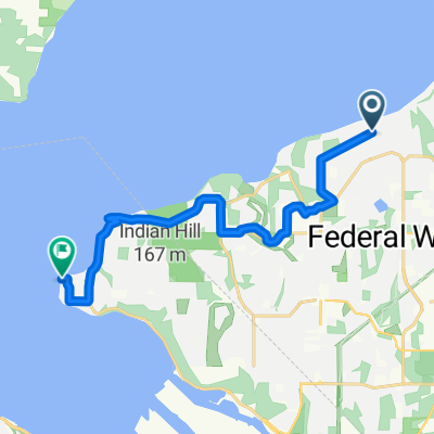
Federal Way to Burien
A cycling route starting in Federal Way, Washington, United States.
Overview
About this route
- -:--
- Duration
- 28.3 km
- Distance
- 416 m
- Ascent
- 391 m
- Descent
- ---
- Avg. speed
- ---
- Max. altitude
Route quality
Waytypes & surfaces along the route
Waytypes
Road
10.2 km
(36 %)
Quiet road
8.8 km
(31 %)
Surfaces
Paved
12.7 km
(45 %)
Asphalt
12.4 km
(44 %)
Concrete
0.3 km
(1 %)
Undefined
15.6 km
(55 %)
Continue with Bikemap
Use, edit, or download this cycling route
You would like to ride Federal Way to Burien or customize it for your own trip? Here is what you can do with this Bikemap route:
Free features
- Save this route as favorite or in collections
- Copy & plan your own version of this route
- Sync your route with Garmin or Wahoo
Premium features
Free trial for 3 days, or one-time payment. More about Bikemap Premium.
- Navigate this route on iOS & Android
- Export a GPX / KML file of this route
- Create your custom printout (try it for free)
- Download this route for offline navigation
Discover more Premium features.
Get Bikemap PremiumFrom our community
Other popular routes starting in Federal Way
 SnL Local Ride BPA 1st Redondo Beach Hills
- Distance
- 25.9 km
- Ascent
- 350 m
- Descent
- 353 m
- Location
- Federal Way, Washington, United States
 27427 12th Pl S, Des Moines to 27427 12th Pl S, Des Moines
- Distance
- 18.6 km
- Ascent
- 257 m
- Descent
- 257 m
- Location
- Federal Way, Washington, United States
 5700 SW Dash Point Rd, Federal Way to 3308 58th Ave NE, Tacoma
- Distance
- 10.8 km
- Ascent
- 301 m
- Descent
- 172 m
- Location
- Federal Way, Washington, United States
 road Bike Home to 59th Ave SW, Seattle
- Distance
- 30.3 km
- Ascent
- 250 m
- Descent
- 330 m
- Location
- Federal Way, Washington, United States
 Home to Alki Trail, Seattle
- Distance
- 31.5 km
- Ascent
- 270 m
- Descent
- 370 m
- Location
- Federal Way, Washington, United States
 Dash Point Park Road, Federal Way to Southwest Dash Point Road 5700, Federal Way
- Distance
- 4.9 km
- Ascent
- 52 m
- Descent
- 51 m
- Location
- Federal Way, Washington, United States
 32426 7th Ave SW, Federal Way to 32430 7th Ave SW, Federal Way
- Distance
- 12.4 km
- Ascent
- 183 m
- Descent
- 184 m
- Location
- Federal Way, Washington, United States
 714 SW 296th St, Federal Way to 201 Tulalip St NE, Tacoma
- Distance
- 13.8 km
- Ascent
- 173 m
- Descent
- 237 m
- Location
- Federal Way, Washington, United States
Open it in the app