

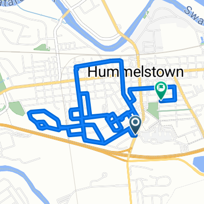
century ride start
A cycling route starting in Hummelstown, Pennsylvania, United States.
Overview
About this route
- -:--
- Duration
- 49.3 km
- Distance
- 293 m
- Ascent
- 273 m
- Descent
- ---
- Avg. speed
- ---
- Max. altitude
Route quality
Waytypes & surfaces along the route
Waytypes
Cycleway
26.1 km
(53 %)
Quiet road
4.4 km
(9 %)
Surfaces
Paved
14.8 km
(30 %)
Unpaved
11.3 km
(23 %)
Asphalt
14.3 km
(29 %)
Gravel
10.3 km
(21 %)
Continue with Bikemap
Use, edit, or download this cycling route
You would like to ride century ride start or customize it for your own trip? Here is what you can do with this Bikemap route:
Free features
- Save this route as favorite or in collections
- Copy & plan your own version of this route
- Sync your route with Garmin or Wahoo
Premium features
Free trial for 3 days, or one-time payment. More about Bikemap Premium.
- Navigate this route on iOS & Android
- Export a GPX / KML file of this route
- Create your custom printout (try it for free)
- Download this route for offline navigation
Discover more Premium features.
Get Bikemap PremiumFrom our community
Other popular routes starting in Hummelstown
 09052016
- Distance
- 11.3 km
- Ascent
- 90 m
- Descent
- 93 m
- Location
- Hummelstown, Pennsylvania, United States
 century ride start
- Distance
- 49.3 km
- Ascent
- 293 m
- Descent
- 273 m
- Location
- Hummelstown, Pennsylvania, United States
 623 W Main St, Hummelstown to 7099 Oak Ridge Dr, Harrisburg
- Distance
- 5.9 km
- Ascent
- 98 m
- Descent
- 55 m
- Location
- Hummelstown, Pennsylvania, United States
 Stonegate Road to County Meadows & back
- Distance
- 12.8 km
- Ascent
- 165 m
- Descent
- 94 m
- Location
- Hummelstown, Pennsylvania, United States
 long flats
- Distance
- 52.3 km
- Ascent
- 281 m
- Descent
- 281 m
- Location
- Hummelstown, Pennsylvania, United States
 South Hanover Street to Poplar Avenue
- Distance
- 8.7 km
- Ascent
- 68 m
- Descent
- 34 m
- Location
- Hummelstown, Pennsylvania, United States
 Bullfrog Valley
- Distance
- 14 km
- Ascent
- 114 m
- Descent
- 162 m
- Location
- Hummelstown, Pennsylvania, United States
 Bullfrog Valley Park to 322
- Distance
- 13.4 km
- Ascent
- 82 m
- Descent
- 79 m
- Location
- Hummelstown, Pennsylvania, United States
Open it in the app